This item has been sold, but you can enter your email address to be notified if another example becomes available.


|
||

|

|
|

|
Stock# 41089
Description
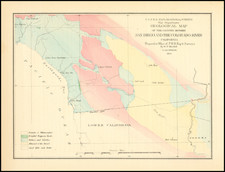
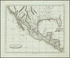
Early map of the California Coastline, showing the roads from San Diego to San Francisco, Sonora and Sacramento.
Prepared by the Adjutant's Office in Monterey, California, the map includes a list of the American Troops in California, 755 in all, not including the Mormon Battalion, whose term of service expired in July 1847.
One of the earliest maps of the California printed in the United States, following annexation.
![[California Road Atlas] Easy Fold Maps of California Highways](https://storage.googleapis.com/raremaps/img/small/73977.jpg)