


|
||

|

|
|

|
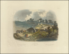
Important early map of the Red River, prepared from the field notes of the Freeman - Custis Expedition in 1806.
The official map of the 1806 Freeman and Custis expedition to the Red River was prepared by Nicholas King, who was Surveyor for the City of Washington, and unofficial cartographer to the Jefferson Administration (1800-1808). King prepared a series of maps at the request of Jefferson's War Department, which represent "the earliest accurate geographical information of the west" (Ehrenberg). These were compiled from the notes and field sketches made by exploring parties sent out by Jefferson to investigate the vast region west of the Mississippi River following the Louisiana Purchase. The most famous of King's maps are the preliminary manuscripts he made of Lewis and Clark's discoveries, and the engraved maps for publication in Zebulon Pike's journal.
Unlike those celebrated expeditions, news of Freeman and Custis's exploration of the Red River was suppressed to avoid a diplomatic incident with Spain. Their journal, An Account of the Red River, in Louisiana, was printed, but apparently only for official use.
The map, which was "little known in its day because of a limited press run" (Charting Louisiana, 126-27), must have been prepared for inclusion in the journal, but then discarded when it became apparent that publication was to be restricted. Th map was unknown to Thomas Streeter, Joseph Sabin, Henry Wagner, or Carl Wheat. Missing from all recorded copies of the journal, it survives in just two loose examples: this recently discovered example from the papers of the nineteenth century U. S. Topographical Engineer, Capt. Washington Hood; and a second in the Library of Congress, which bears the accession stamp of the Office of the Engineers, a branch of the US Army. The survival of the map was not known until 1971, when Ralph Ehrenberg, with access to the Office of the Engineers copy (subsequently transferred to the Library of Congress), mentioned it in his article on Nicholas King. There is speculation that this copy of the map was part of the Peter Force papers, which were acquired by the Library of Congress in 1877.
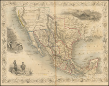
King's map of the Freeman and Custis expedition is the first to show any part of Texas based on U.S. government exploration. Shortly after Jefferson dispatched Lewis and Clark to explore the northern part of the Louisiana Purchase, he ordered Thomas Freeman and Peter Custis to survey the course and headwaters of the Red River, recognized as Louisiana's southern boundary. The expedition was the largest American exploring party of the age, even larger than that of Lewis and Clark. At some point, the expedition was turned back by an overwhelming Spanish force.
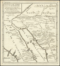
The lack of access to the map, coupled with ambiguities in the journal, led to a debate among historians as to how far up the Red River the expedition advanced. Streeter notes that "Map makers and later writers are far from agreement as to where on the Red River Freeman was halted by Captain Viana", and gives a summary of the competing theories. The crux of the issue was whether Freeman and Custis traveled far enough to become the first United States expedition to enter present-day Texas. The map is the crucial bit of evidence, and proves that they advanced up the Red River as far as the neighborhood of New Boston, in Bowie County, Texas.
For the Red River, from its confluence with the Mississippi to the point of advance, this is by far the most accurate map published to its time. A short distance above Natchitoches, the starting point of the expedition, and the last American settlement on the river, is the famous "Great Raft". This was a massive logjam, one hundred miles in length, and estimated to be a thousand years old. It took the expedition over two weeks to detour around the raft and reconnect with the river. Further on, the maps locates the various Caddo and Coashatta Indian villages, and the "Trading Path from Caddo's to Arkansas".
Washington Hood (1808-1840), U. S. Topographical Engineer, graduated from West Point in 1827. He surveyed the Ohio-Michigan border with Robert E. Lee in 1835, and then prepared an important map of Oregon West of the Rocky Mountains (1838), that was included in several reports and government documents. In 1839, President Van Buren sent Hood to survey the Shawnee Timberlands bordering Arkansas and Missouri, where he contracted a fatal disease and died the following year. DAB IX, pp. 194-95. Hood's papers are at the Winterthur Library (Joseph Downs Collection), and include a ms. map in his hand entitled Military Survey of the Country between the Arkansas & Red Rivers … 1838. King's map may have come into Hood's hands in conjunction with the preparation of that map.
![[Montana, Wyoming, Colorado, Dakotas, etc] Reconnaissances in the Dacota Country By G.K. Warren](https://storage.googleapis.com/raremaps/img/small/82655.jpg)

![[Florida Panhandle to Yucatan] Pas-Kaart Van de Golff van Mexico . . .](https://storage.googleapis.com/raremaps/img/small/93130.jpg)