This item has been sold, but you can enter your email address to be notified if another example becomes available.


|
||

|

|
|

|
Stock# 40906
Description
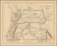
Interesting map of the West, focusing in on the major railroad and steamship lines in the region.
The map was prepared to accompany the Report on the Internal Commerce of the United States, By Joseph Nimmo, Jr. Chief of the Bureau of Statistics, Treasury Department, submitted on May 6, 1885. This report focused on "the commercial, industrial, and transportation interests of the Pacific Coast . . . "
Includes a large inset map of the the San Francisco Bay area. Major lines referenced include:
- Southern Pacific RR
- Northern Pacific RR
- California Southern RR
- Atlantic & Pacific RR
- Carson City & Colorado RR
- Central Pacific RR
- Oregon & California RR
- Oregon Branch of the Northwestern RR
- Oregon Railway & Navigation Co
- Oregon Short Line
- Cascade Branch of Northern Pacific RR
- Canadian Pacific RR
- Utah Northern Branch of Union Pacific RR
- Denver & Rio Grande RR
- Utah Southern RR
- Nevada Central RR
- Eureka & Palisades RR
- Salt Lake & Western RR
- Utah & Nevada RR
- Colorado Central RR
- Denver Pacific RR
- Atchison Topeka & Santa Fe RR
- Sonora Railway
- Mexico Central RR
A nice overview of Western commercial transportion during this period. The map and report are apparently quite rare on the market, this being the first example we have ever seen.
![Central Route to the Pacific, From The Valley of the Mississippi To California. Journal of The Expedition of E.F. Beale, Superintendant of Indian Affairs In California, And Gwinn Harris Heap, From Missouri To California [with map:] Map of the Central Route from the Valley of the Mississippi to California](https://storage.googleapis.com/raremaps/img/small/99222.jpg)

![[California Wine Advertising Graphic] Italian Swiss Colony Producers of Choicest California Wines Asti Colony Tipo](https://storage.googleapis.com/raremaps/img/small/83467.jpg)