|
||

|

|
|

|
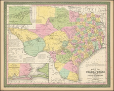
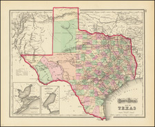
Unrecorded proof state of Burr's map of Texas, one of the two most important maps of Texas on the eve of its independence.
The map is of the utmost importance in the history of Texas, both as an early milestone in its development and as one of the earliest useful guide maps to the region. Of the 5 recorded states of the map (1833, 1834, 1835, 1845 and 1846), the 1833 is the rarest, with only a handful of copies known in American institutional collections. For example, the Libarry of Congress and most major Texas collections do not include this first state.
The present state is apparently a proof state of the 1833, lacking the inclusion of the names Nacogdoches and Bolivar, but with the name Nacogdoches added in an early hand. The only other example of the map pre-dating the inclusion of these two place names appeared at auction in 2001, and included the two names (Nacogdoches and Bolivar) added in the same early hand.
This example of the map is signed twice on the verso by Bernhard Scherrer and Mr. Albert Knolle, College Station. Bernhard Scherrer was among the earliest settlers in Texas. Scherrer came to the United States in 1829, from St. Gallen, Switzerland, and settled at Biegel, Fayette County, in 1833, spending the remaining years of his life there as a successful planter. Scherrer's daughter Caroline Scherrer married Ernst Hermann Knolle. Albert was apparently their son, as at least 2 genealogical sites reference an Albert Knolle, born to Herman Knolle and wife Caroline in 1870 in Fayette, Texas.
David H. Burr studied law, passing the New York Bar Exam, and then surveying under Simeon DeWitt in New York. His first atlas was an atlas of New York State (1829), the second state atlas to be issued in the US (after Mills’ Atlas of South Carolina in 1826). In the 1830s, he served as the official topographer for the US Post Office, producing a series of rare and highly sought-after large-format state maps. He also created a map of the country’s postal routes, which features roads, canals, and railroads. Burr traveled to London to work with John Arrowsmith; together, they produced the American Atlas in 1839.
Upon his return to the States, Burr was appointed as a draftsman for the House of Representatives, where he worked until ca. 1841. He later worked for the Louisiana Survey and the Florida Survey. By 1850, he was back in Washington D. C., working on the census. In 1852, the Senate named Burr as the draftsman to compile maps from the Federal Surveys. In 1853, Burr traveled to San Francisco, perhaps as part of his work for the Senate. He was then named as the Surveyor General of Utah in 1855. However, he was unpopular there and returned to Washington D. C. by 1870. Burr is widely regarded as one of the most important names in the nineteenth-century American history of cartography.

![Texas [Arkansas on verso]](https://storage.googleapis.com/raremaps/img/small/99448.jpg)