


|
||

|

|
|

|
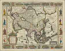
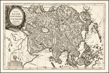
Striking large format map of Asia, first published by Hubert Jaillot.
First issued in 1674, this two sheet map of Asia provides a highly detailed picture of the continent, based upon the geographical compilations and work of Nicolas Sanson which remained unpublished at the time of his death. Jaillot conceived in 1674 of the re-issue of Sanson's major work (published and unpublished) in an enlarged format.
The maps were issued as early as 1674 and were later jointly issued by Mortier and later by Covens & Mortier, in Amsterdam.
Cornelis Mortier (1699-1783) was a Dutch publisher who specialized in geography. Cornelis’ father, Pierre Mortier the Elder (1661-1711), had obtained a privilege in 1690 to distribute the works of French geographers in the Netherlands. After his widow continued the business for several years, Cornelis took over in 1719.
In 1721, Mortier forged a partnership with Johannes Covens, who had recently married Cornelis’ sister. They published under the joint name of Covens & Mortier. Their firm was one of the largest and most successful in Dutch history and continued in business until the late-nineteenth century.
In 1774, upon the death of his father, Johannes Covens II (1722-1794) took over his father’s share. In 1778, the company changed its name to J. Covens & Zoon, or J. Covens & Son. Covens II’s son, Cornelis (1764-1825), later inherited the business and brought Petrus Mortier IV back into the fold. Petrus was the great-grandson of Petrus Mortier I. From 1794, the business was called Mortier, Covens & Zoon, or Mortier, Covens, & Son.
The business specialized in publishing French geographers including Deslisle, Jaillot, and Sanson. They also published atlases, for example a 1725 reissue of Frederik de Wit’s Atlas Major and an atlas, with additions, from the works of Guillaume Delisle. There were also Covens & Mortier pocket atlases and town atlases. The company profited from acquiring plates from other geographers as well. For example, the purchased Pieter van der Aa’s plates in 1730. Finally, they also compiled a few maps in house. At their height, they had the largest collection of geographic prints ever assembled in Amsterdam.
![[6 Sheet Wall Map of Asia] L'Asie divisee suivant l'Estendue de ses Principales Parties dans lesquelles sont distinguees les unes de autres Les Empires, Monarchies, Estats et Principaux Peuples qui partagent a present L'Asie . . . 1719](https://storage.googleapis.com/raremaps/img/small/80841.jpg)