


|
||

|

|
|

|
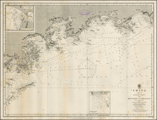
A striking example of Waldseemuller's modern map of the Indian Ocean, India, Southeast Asia and contiguous regions, from the 1513 edition of Waldseemuller's Geographia.
Waldseemuller's modern map covers most of Southern Asia and is centered on the Indian Ocean, extending from Arabia and the Horn of Africa to the Malay Peninsula and northward toward China. The map is based largely upon the Cantino world map of 1502 and the Ruysch world map of 1507.
As noted by Greg McIntosh,
the depictions of the Old World, especially the seas, peninsulas, and placenames of the littoral of the Indian Ocean, Red Sea, Persian Gulf, Arabian Sea, and Bay of Bengal . . . are derived, not from multiple introductions of Portuguese cartography into Italian cartography, but by the introduction of that Old World image in a single event, that is, the arrival of the Cantino planisphere in Genoa in November 1502 and its subsequent dissemination through traditional manuscript copying processes, particularly via the highly influential copy made by Nicolay de Caverio. . . .
Regarding the transmission of placenames from the Cantino planisphere (1502) to the Caverio planisphere (c. 1503-04), and from the Caverio to Martin Waldseemüller, and from the Waldseemüller maps (1507-1516) to those of Schöner, Fries, Honter, and others (1515-1546), not only can we track, via placenames, inscriptions, and iconography, the maps-as-texts over a period of time, and not only can we see in each map the outcome or end result of a particular instance of the copying of large portions of manuscript text (placenames), but we can also watch some of the copying process by each individual mapmaker as it unfolds.
The map is considered by some (see Suarez, Early Mapping of Southeast Asia) to be the first modern map of Asia. Cartographically, the map draws heavily from the Portugese discoveries first documented on Cantino's map. The Waldseemüller map follows the Cantino delineation with an arrow-shaped Indian subcontinent and a Malay peninsula, which is greatly exaggerated and extends too far south.
Waldseemuller's map is the first to depict Sinus Magnus as the South China Sea. The small peninsula of 'Fulicandora', located directly above Sinus Magnus, represents the first earliest appearance of Indochina on a printed map.
Sri Lanka and the Indian subcontinent are relatively correct in their sizes. This map is among the earliest documents recording the Portugese explorations into the Indian Ocean, and is of primary importance in the mapping of the India and Southeast Asia.
The first modern atlas, prepared by Martin Waldseemuller using the translation of Mathias Ringmann. This is one of the most important editions of Ptolemy, containing many new regional maps. Twenty new maps based on contemporary knowledge were included by Waldseemuller, in addition to the traditional twenty-seven Ptolemaic maps derived from the 1482 Ulm edition.
Martin Waldseemuller and his associate Mathias Ringmann, prepared this edition of Ptolemy, partly at the expense of Duke Rene of Lorraine. It was brought to completion by Jacobus Eszler and Georgius Ubelin. The atlas contains the first map in an atlas entirely devoted to America (Tabula terre nove), often called the "Admiral's map" after Columbus. The map of Lotharingia (the first map of the Duchy of Lorrain), printed in black, red and olive, is one the earliest examples of color-printing. This edition was reprinted in 1520 using the same woodcut blocks.
Martin Waldseemüller (c. 1475-1520) was a sixteenth-century cosmographer best known for his 1507 world map in twelve sheets, the earliest surviving map to include the name “America.” He was an influential mapmaker during his time whose work affected many of his contemporaries and successors. Waldseemüller was born near Freiburg, in what is now southwestern Germany. His family moved to Freiburg proper when he was young and he attended university in the city beginning in 1490.
Waldseemüller gathered information about the New World discoveries and geography from St.-Dié des Vosges in Lorraine, where he was a professor of cosmography under the patronage of René II, Duke of Lorraine. He was a member of an intellectual circle who produced work from the St.-Dié Press. However, the press failed when the Duke died, and Waldseemüller moved to Strasbourg.
He is best known for the 1507 map and another world projection, the Carta Marina published in 1516. He also published an edition of Ptolemy in 1513, in collaboration with Johann Schott, a friend from Freiburg and St.-Dié. Besides his innovative use of the toponym “America”, Waldseemüller was the first to create such a large printed world map, the author of the earliest known printed globe gores, the first to create a published collection of modern maps, and one of the first to create maps from ground measurements. He was knowledgeable in surveying methods and designed a quadrant and other instruments. He returned to St.-Dié late in life as canon, although he continued to return to Strasbourg for work and for carnival. He died in St.-Dié in 1520.
Waldseemuller is generally credited with having named the continent of America, based upon the then current belief that Amerigo Vespucci had been the first modern explorer to reach the continent of America in 1497, during the first of four expeditions to America which were then credited to Vespucci between 1497 and 1504. The report which described the 1497 expedition is now generally believed to be a forgery. Later in his career, Waldseemüller elected not to use the toponym for the continents, preferring to leave them unnamed. However, the name had been taken up by his contemporaries, in large part due to the influential nature of Waldseemüller’s earlier works.
![(World War II - Free French Forces Mapping) Beyrouth Ville [Beirut City] [on verso:] Lattaquié [Latakia]](https://storage.googleapis.com/raremaps/img/small/88805.jpg)
![Tabula Asiae VII [Iran, Afghanistan, Turkmenistan, Uzbekistan, Kazakhastan, Pakistan, India]](https://storage.googleapis.com/raremaps/img/small/77558.jpg)
![[Armenia] Armenia Vetus In Quattuor Partes distincta ad Tepora Iustiniana Imp. . . . 1653](https://storage.googleapis.com/raremaps/img/small/91739.jpg)