
The item illustrated and described below is sold, but we
have another example in stock. To view the example which
is currently being offered for sale, click the
"View Details" button below.


|
||

|

|
|

|
Stock# 40781
Description
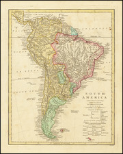
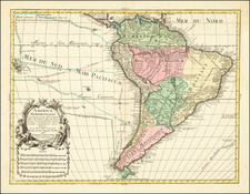
A detailed map of the continent, which is just now filling in its Amazonian details. Map shows the Spanish and Portuguese Territories, French, Dutch and British Possessions and native locations.
The territorial configuration of the map corresponds with the beginning of South America's Revolutionary period, with each of the European powers losing most of their territories over the next 30 years. An interesting and highly detailed map.
Robert Wilkinson was active in London as a cartographic publisher from 1785 to 1825. He produced a number of nice works, including a General Atlas and a re-issuance of Bowen & Kitchen's English Atlas, along with excellent large format separate maps.
![Pascaart vertoonende de zeecusten van Chili, Peru, Hispania Nova, Nova Granada, en California…. [Early New Zealand Inset]](https://storage.googleapis.com/raremaps/img/small/65168.jpg)