


|
||

|

|
|

|
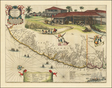
Nice example of the Johannes Blaeu edition of Barleus' map of a portion of Brazil, which first appeared in Barleus's from his ervm per Octennivm in Brasilia et alibi nuper gesterum sub Praefectura Illustrissimi Comitis I. Mavritii, Nassoviae, &c…published by Blaeu in 1647.
This spectacular map of the Brazilian coastline covers the capitanias of Pernambuca and I. Tamarica. This map is one the first maps of Brazil based on Dutch rather than Portuguese interest. The Dutch West India Company, appointed Count Johan Maurits Governor-General of Dutch Brazil in 1636. He remained in power until 1644. Upon Maurits return to Europe, he commissioned Kaspar van Baerle to document the flora and fauna, climate, inhabitants, religion, and languages of the coastal provinces of Brazil. The resulting work, Rerum per octennium in Brasilia published by Blaeu, is one of the finest works of Brazil ever produced. The maps in this work, with alterations, later appeared in later editions Blaeu's Atlas Major and composite atlases by Mortier. This detailed map is highly embellished with cartouches, coats of arms, ships and a sea battle. The large scene on the upper quarter of the map depicts the commercially important sugar cane industry.
Blaeu first issued this and its companion maps in 1647 for Gaspar Barleus' Rerum per octennium in Brasilia. They were also assembled into a large wall map, Brasilia qua parte paret Belgis; the places where the sheets overlapped are marked by faint lines at left. The maps then appeared in the Atlas Maior beginning in 1662.
Joan, or Johannes, Blaeu (1596-1673) was the son of Willem Janszoon Blaeu. He inherited his father’s meticulous and striking mapmaking style and continued the Blaeu workshop until it burned in 1672. Initially, Joan trained as a lawyer, but he decided to join his father’s business rather than practice.
After his father’s death in 1638, Joan and his brother, Cornelis, took over their father’s shop and Joan took on his work as hydrographer to the Dutch East India Company. Joan brought out many important works, including Nova et Accuratissima Terrarum Orbis Tabula, a world map to commemorate the Peace of Westphalia which brought news of Abel Tasman’s voyages in the Pacific to the attention of Europe. This map was used as a template for the world map set in the floor of the Amsterdam Town Hall, the Groote Burger-Zaal, in 1655.
Joan also modified and greatly expanded his father’s Atlas novus, first published in 1635. All the while, Joan was honing his own atlas. He published the Atlas maior between 1662 and 1672. It is one of the most sought-after atlases by collectors and institutions today due to the attention to the detail, quality, and beauty of the maps. He is also known for his town plans and wall maps of the continents. Joan’s productivity slammed to a halt in 1672, when a fire completely destroyed his workshop and stock. Joan died a year later and is buried in the Westerkerk in Amsterdam.

![[ Ilha da Santa Catarina to Bombinhas ]](https://storage.googleapis.com/raremaps/img/small/59596.jpg)
![[ Rio de Janeiro ] Planta Informativa Do Centro Da Cidade Do Rio De Janeiro. Especialmente Organisada Para o Guia Briguiet Pelo Professor Arthur Duarte Ribeiro . . . 1932](https://storage.googleapis.com/raremaps/img/small/66693.jpg)