|
||

|

|
|

|
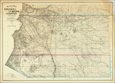
Fascinating map of the Navajo Lands in the eastern Arizona, western New Mexico and southern Utah, focusing on available water sources and irrigation projects being considered by the Department of the Interior, prepared in the second half of 1892.
The Navajo Reservation is the largest Indian reservation in the United States. After the Long Walk and the Navajos' return from their imprisonment in Bosque Redondo, the "Navajo Indian Reservation" was established according to the Treaty of 1868 with the United States. The borders were defined as the 37th parallel in the North; the southern border as a line running through Fort Defiance; the eastern border as a line running through Fort Lyon; and in the West as longitude 109 o30'. Between 1878 and 1934, the reservation was expanded on numerous occasions, until it reached its present size.
The map extends from the area of Gallup, New Mexico and Fort Wingate in the Southeast, Farmington, New Mexico in the Northeast, Glen Canyon, Utah in the Northwest and Gray Mountain in the southwest, centered on the modern day Reservations of the Navajo Nation and the Hopi. The focal point of the map is clearly water and irrigation. In addition to contour details, the map focuses on Springs, Rivers, Creeks and numerous irrigation ditches. The map also identifies its primary makers in the body of the map, showing the routes taken by each in undertaking these work in 1892, including:
- Lieutenant Odon Gurovits, Eleventh Cavalry
- Lieutenant E. M. Suplee, Second Cavalry
- Lieutenant W.C. Brown, First Cavalry As such, this would seem to be an extremely rare example of the topographical map intended to accompany Senate Executive Document No. 68, 52 2 the Message From The President of the United States, Transmitting Certain Reports upon the condition of the Navajo Indian Country, dated February 14, 1893.
The report begins:
On August 1, 1892, this Department [of the Interior] had the honor to submit to you a communication from the Commissioner of Indian Affairs relative to the situation among the Navajo Indians in New Mexico and Arizona, wherein he recommended that the plan suggested by Gen. McCook to Redistrict the Navajo country into suitable portions and to detail proper officer to thoroughly inspect the entire region, make a countour map of it, and submit a detailed report, so that tis Department could be advised as to the practicability of restraining Navajoes within thie present reservation and of furnishing irrigation and water for their flocks, with request that the necessary instructions might be given to the honorable Secretary of War to carry out the recommendations their contained.
I now hav the honor to transmit copy of communication of the 29th December las from the honorable Secretary of War, transmitting reports of Lieuts. Brown, Gurovits and Suplee, U.S. Army, the officers charged with the duty, together with notes and explanatory maps . . .
As the papers and maps are quite voluminous, only one copy of the same is furnished, and it is requested that this copy be sent to the Senate . . .
John Noble, Secretary
Later, in the same report, the Assistant Secretary of War writes:
Should these reports and maps at any time e printed under the direction of your Department, I would be very glad if you would cause a few copies to be sent for the files of the War Department. . .
Later, in the same report, the Engineer's Office from the Department of Arizona writes:
. . . In view of the well-known character and extent of the Navajo Reservation, it would be plainly impossible to do all the work recommended by Commissioner Morgan in his communication of July 30,1892, in the limited time indicated therein. It would require at least two years for the completion of a topographical survey "so that a proper and correct map can be made of the 12,821 square miles which constitute teh Navajo Reservation," a territory larger than the combined areas of Connecticut and Massachusetts.
These recommendations made by Gurovits, Brown and Suplee for improving the use of water resources on the Navajo Nation Reservation would be the subject matter of discussion and implementation for the next several decades.
The map would appear to be very rare. We have been unable to locate any other examples, although the lack of a title makes for a very difficult search.