|
||

|

|
|

|
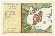
Fine early map of Boston, engraved by Samuel Hill and prepared by Osgood Carleton for The Boston Directory, by Manning & Loring, for John West, No. 75, Cornhill. June 1796.
As noted by Michael Buehler in his on-line cataloguing of the map:
the plan's focus on the Shawmut Peninsula enables it to depict the area in considerable detail. The street grid is shown with streets and wharves named, and other landmarks such as Fort Hill, the Mill Pond and Boston Common are indicated. Nine important buildings are numbered and identified by a legend at lower right.
In Mapping Boston, Cobb notes:
Carleton's map is the first detailed map of the town since the Revolutionary era and shows some of the changes that had occurred in the interim: ropewalks had been relocated from Fort Hill to newly made land at the foot of the Common, South Battery had been replaced by Rowes Wharf, and the part of the Town Dock north of Fanueil Hall had been filled in. The first two bridges constructed to provide new connections between the Boston peninsula and the mainland, indicated on [Carleton's] 1795 plan, are more clearly shown here as the extensions of Cambridge Street and Pine Street.
The map was revised and re-issued several times over the next decade, beginning in 1805.
The map is scarce on the market. We note only 2 examples in AMPR, none in the past 15 years.