|
||

|

|
|

|
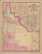
Interesting promotional letter sheet map of the area around Weiser, Idaho, with a letter on the verso referencing the Weiser Irrigation District -- Washington County, Idaho.
The map is centered on Weiser, Idaho, and extends southeast to Boise, Idaho, north to Lewiston, Idaho, west to Burns and Vale, Oregon, and northwest to La Grande, Oregon.
The map shows gold mining regions, silver, copper, grazing lands, commercial timber, etc., with Wagon Roads, Irrigation Canals, Railroads and Proposed Railroads noted. The promotional literature is quite impressive for the period, including the following excerpt:
This is not a map of the World. But the country shown is a world itself. Why? Because within its limits you can find or produce nearly everyting the world needs. . . . Note the vast area of fine agricultural land . . . and the mountains seamed with veins of gold, silver . . . and other metals. The gold fields of Malheur are but a day's travel. . . The best and healthiest climate on earth. More sunshine, no thunderstorms, cyclones or blizzards. Weiser has electric lights and water works, and a state bridge built across the snake river at a cost of $30,000, which unites us with all of Oregon Territory . . . Weiser is the "PROMISED LAND" for the homeseeker.
Who could resist!
Weiser was named after the nearby Weiser River, but exactly who that was named for is not precisely known. In one version it is for Peter M. Weiser, a soldier and member of the Lewis and Clark Expedition of 1804-1806. Another has it for Jacob Weiser, a trapper-turned-miner who struck it rich in Baboon Gulch in the Florence Basin of Idaho in 1861. William Logan and his wife settled in the vicinity of Weiser in 1863, building a roadhouse in anticipation of the opening of Olds Ferry west of them on the Snake River across from Farewell Bend. In 1863, Reuben Olds acquired a franchise from the Territorial Legislature and began operating Olds Ferry. Olds ferry business did well (as did Logan's) as it diverted much of the traffic from the old Snake River crossing point at Old Fort Boise. Increasing settlement on the Weiser River valley increased Weiser's population. A post office was established in 1866 as Weiser Ranch. In 1871, it was renamed Weiser.
Weiser reached its height of prosperity when a railroad way station was established and it became a transportation hub for travelers.
During the 1890s, the city had pretensions of becoming a major regional market and transportation center. The Idaho Northern Railroad was built up the Weiser River with the intention of reaching Lewiston and river transportation to the ocean. The dream ended among the lumber mills of central Idaho, almost at the community of Meadows... not needing to actually go past the stock loading and lumber ponds outside the village, the terminus station was built there and a new city, New Meadows, came into being. Likewise the Union Pacific, after taking over the Oregon Short Line, chose not to locate its major section yards in the flats west of Weiser-probably due to inflated prices asked by land speculators-and built at Huntington, Oregon, at the western edge of the Snake River valley.

![Johnson's Washington Oregon and Idaho [Massive Dakota Territory]](https://storage.googleapis.com/raremaps/img/small/98348.jpg)