|
||

|

|
|

|
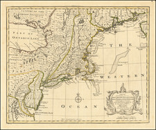
Nice example of Van Loon's rare sea chart of the East Coast of North America, from Cape Cod to the Outer Banks of the Carolinas, from Van Loon's Klaer Lichtende Noort-Ster ofte Zee Atlas, first published in 1661.
The map illustrates the Atlantic coast of America from Cape Cod to Cape Hatteras. The emphasis is on the Dutch colony of New Netherland. New Amsterdam (New York) is shown at the tip of Manhattan Island. Many other Dutch place names appear, including Staten Eylandt, Lange Eylandt, and Vlysingen (Flushing). Along the Delaware River a number of Dutch settlements are shown, including Fort Casimir, Nassau and Elsenburgh, as well as the Swedish Fort Christina. The Schuylkill River, future site of Philadelphia, is also shown. In New England, Martha's Vineyard and Nantucket are shown with their present names, and several early English settlements, such as New Plymouth are located. Excellent early delineation of the Chesapeake Bay, with Jamestown located. The Potomac River is shown as the Patwomeck.
Van Loon's map bears some visual similarities to the 1660 Hendrik Doncker chart and the 1666 Pieter Goos chart of the same region, but on close inspection, is very different:
Doncker: www.raremaps.com/gallery/detail/19156
Van Loon's chart shows significant advancements from the Doncker chart. The coastline of New England is vastly improved, extending further north, following the Jansson-Visscher maps series. Cape Cod is more accurately located. Narrangansett Bay is shown, being named Rood Eylant. The coatline of New Jersey is significantly improved, showing the outer sand banks.
Five years later, in 1666, Pieter Goos would issue a near exact copy of Van Loon's chart.
Van Loon's map is rare on the market. This is the first example we have ever seen on the market.
![[Hand Drawn Map] Le Golfe de Mexique avec les Pays Circonvoisins](https://storage.googleapis.com/raremaps/img/small/91580.jpg)
![[ Cape Hatteras to New York City ] The Coast of the United States of North America; from New York to St. Augustine: Drawn and regulated according to the latest Surveys and Astronomical Observations By Edmund Blunt. Additions to 1839 & 1840](https://storage.googleapis.com/raremaps/img/small/84684.jpg)