
This item has been sold, but you can enter your email address to be notified if another example becomes available.


|
||

|

|
|

|
Stock# 40551
Description
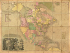
Interesting early map of North America, pre-dating the discoveries of Lewis & Clark.
No sign of the Rocky Mountains. Good pre-Lewis & Clark treatment of the Missiouri and Mississippi Rivers. Louisiana dominates the continent. Quivira, Teguayo and New Albion are shown in the West, as is Texas. The US Extends to the Mississippi, but pre-dates Tennessee, Kentucky and Ohio.
The NW Passage is clearly shown, along with a pre-Vancouver, post-Cook treatment of the NW Coast. San Diego, Sir Francis Drake Harbor, Monterey and San Pedro are shown in California. Many Indian Tribes named.
![[Signed Political Satire Artwork] Vietnam ... Vietnam ... Vietnam ...](https://storage.googleapis.com/raremaps/img/small/68726.jpg)

![A New and Correct Map of North America with the West India Islands, Divided According to the Last Treaty of Peace ... 20th of Jan. 1783 ... Particularly Distinguished the Thirteen Provinces which Compose the United States . . . [With annotations describing Cumberland, Tennessee, Kentucky etc.]](https://storage.googleapis.com/raremaps/img/small/41651.jpg)
![Amerique Septentrionale divisee en Ses Principales parties . . . . 1692 [California as an Island]](https://storage.googleapis.com/raremaps/img/small/95812.jpg)
![Tabula Terre Nove [The Admiral's Map]](https://storage.googleapis.com/raremaps/img/small/81714.jpg)