|
||

|

|
|

|
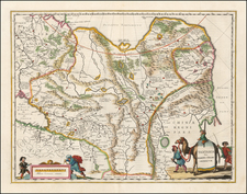
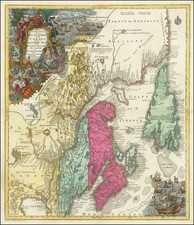
Foundational Map for The Great Myth of the Sea of The West
Fine example of this very rare and important map depicting the apocryphal 'Mer de l'Ouest' and the Strait of Anian by Joseph-Nicholas de L'Isle, which were at the center of one of history's most heated cartographic debates about the existence of the Northwest Passage.
The map was prepared by the prominent, yet controversial cartographer Joseph-Nicholas de L'Isle, and published as part of his rare pamphlet, Nouvelles cartes des decouvertes de l'Amiral de Fonte, et autres navigateurs espagnols, portugais, anglois, hollandois, françois et russes, dans les mers septentrionales (Paris, 1753).
Meticulously compiled by Joseph-Nicholas De L'Isle from the work of his older brother, Guillaume De L'Isle, and information obtained by Joseph Nicholas during his time in Russia at the Royal Academy in St. Petersburg. The map synthesizes the information of Russian explorers in the first half of the 18th Century, including Spanberg, Tchirkow, Berhing and others to resurrect the myths of De Fonte and Aguilar and present the information as suggestive of both the Sea of the West and a very direct Northwest Passage reported by De Fonte immediately north of the Sea of the west and a nearly complete transit even further north via the so-called Lac Bernarda.
The map depicts the late Guillaume De L'Isle's conception of the Mer de l'Ouest, the great apocryphal sea that occupied much of western North America, which Guillaume had sketched in manuscript on several maps, but had never reduced to print, taking the form of a massive round sea, which opens to the Pacific around the place of modern day Oregon. The map further depicts the Northwest Passage, as claimed to have been discovered by the Admiral Bartholomew Fonte, an apocryphal Spanish naval officer. A letter supposedly by Fonte, dated 1640, was first published in London in the Memoirs of the Curious (1706). In this letter, Fonte claimed that he was ordered by his king to sail from Callao, Peru, northwards up the coast. Upon his journey, he claimed that he encountered a ship from Boston that had traversed the Northwest Passage, sailing through the 'Detroit d'Anian', as shown on the map. While Fonte's letter is now universally considered to have been a hoax, the story it told proved to be highly influential throughout much of the 18th-century.
Guillame de L'Isle continually experimented with new theories and discoveries in the sketches he made in preparation for his printed maps. It is known that Guillaume drew at least one manuscript map depicting the supposed Mer de l'Ouest. Critically, De L'Isle never included this information on any of his published maps. Following Guillaume's death in 1726, Joseph-Nicolas found the manuscript map in his brother's papers, and evidently decided to keep it out of the public eye for some years.
While Guillaume De L'Isle had never issued a printed map in support of his theoretical Bay of the West, his competitor, J.B. Nolin had in fact issued such a map, which was in turn copied by Pierre Mortier in Amsterdam. /gallery/detail/39749 The short-lived history of the first appearance of the Bay of the west at the beginning of the 18th Century supports that theory that it was likely rejected by Guillaume De L'Isle or simply omitted from printed maps for lack of adequate proof.
Joseph-Nicolas de L'Isle (1688-1768) was French geographer and the younger brother of Guillaume de L'Isle (1675-1726), mapmaker to the King of France. Joseph-Nicolas De L'Isle served as the head of the Russian Imperial Academy of Sciences in St. Petersburg from 1726-47, at which time he had access to the information then being transmitted to St. Petersburg by the Russian explorers in the North Pacific. From 1733 onwards a series of Russian expedtions under the leadership of Vitus Bering reached Alaska, making the first step towards the mapping of the Pacific Northwest of North America. Upon his return to Paris from St. Petersburg in 1747, De L'Isle began disseminating much of what he learned while in the service of the Russian Academy, a disclosure which greatly angered his former Russian employers.
Upon his return to France, one of Joseph-Nicolas de L'Isle's obsessions, which he shared with his nephew (by marriage), the cartographer Philippe Buache, was mapping the apocryphal Mer de l'Ouest and the alternative theory of the Strait of Anian.
De L'Isle and Buache first worked together on a manuscript map that was presented to the Academy Royale in 1750, and was in good part based on Guillaume De L'Isle's manuscript. This formed the basis of a map that was subsequently published by Buache, the Carte Des Nouvelles Decouvertes Au Nord de la Mer de Sud (Paris, 1752), although it featured some notable amendments.
De L'Isle was displeased by how Buache altered the details featured in their joint manuscript for the printed version, and this led to a falling out between the two cartographers. In response, the following year, De L'Isle wrote the Nouvelles cartes des decouvertes as a reprise, in good part, to properly represent his late brother's work.
De L'Isle's Nouvelles cartes des decouvertes contains 4 maps which are placed at the end of the pamphlet after the 60 pages of text. The map is historically important, as it helped to reignite a great intellectual debate about the nature of the North Pacific, and whether the Northwest Passage truly existed. The matter was of great consequence, as the discovery of Northwest Passage would revolutionize international commerce and navigation. England, France, Spain and Russia dedicated vast resources to solving the mystery, and Europe's greatest intellectuals pondered the question. Many of the leading mapmakers, such as Robert de Vaugondy and Thomas Jefferys, sought to portray the Mer de l'Ouest and its supposed connection to a transcontinental passage. Denis Diderot focused heavily on the debate in his monumental L'Encyclopedie (1751-1772), the single most influential publication of the Enlightenment era.
The Third Voyage of Captain James Cook (1776-1780) and the subsequent expeditions of George Vancouver and various Spanish navigators definitely disproved the existence of the Mer de l'Ouest, the Strait of Anian, or any other passage running through the interior of the North American continent.
The chart is dedicated to Antoine-Louis Rouille, Chevalier Comte de Jouy, &c., the French Scretary of State of the Navy. He was in succession conseiller to the parlement de Paris (1711), maître des requêtes (1717), intendant of commerce (1725), conseiller d'État, and finally commissaire to the French East India Company (1744). Named Secretary of State for the Navy to replace Maurepas, he worked to reorganize the French Navy. He left this ministry in July 1754 to hold that of Foreign Secretary. As Foreign Secretary, Rouillé generally pursued a pacific policy, trying to avoid escalation of the increasingly bitter colonial feud with Britain in North America. Rouillé was unable to prevent the escalation of the Anglo-French conflict into open war in 1756. Although he had little to do with the diplomatic maneuvers which led to the Diplomatic Revolution of 1756, Rouillé, as Foreign Secretary, was one of the French signatories of the first Treaty of Versailles (1756), which joined France and Austria together in an alliance.
The present map and the pamphlet in which it appeared are very rare. We are not aware of any of the maps from the Nouvelles cartes des decouvertes appearing separately on the market during the last 25 years and the pamphlet has appeared only once in a dealer's catalog and once at auction during the same period.
![[ Polar Regions ] Pais qui Dependent de la Norvege Suivant les Derniers Relations Par N. de Fer.](https://storage.googleapis.com/raremaps/img/small/100688.jpg)