This item has been sold, but you can enter your email address to be notified if another example becomes available.


|
||

|

|
|

|
Stock# 40508
Description
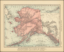
Interesting early map of Alaska, published at about the same time as the discovery of Gold in Alaska and the Yukon River would spur the Alaskan Gold Rush.
The map focuses on various settlements in Alaska, along with Churches, where applicable. Dawson, Ft. Cudahy and Ft. Yukon are noted, along with Ft. Hamlin, Ft. Adams and Rampart House in the area where gold would be discovered.
A smaller version of this map was first published in 1886 to accompany a report to the General Agent of Education and was periodically re-issued over the years. We note editions of 1885 (2 editions), 1897 and 1905. Each map is a different size and apparently unique.
Condition Description
Folding map, with original pamphlet.
![[ Alaska ] U.S. Coast Survey — Explorations in Alaska By the Party under the direction of WH. Dall, Assistant. 1874](https://storage.googleapis.com/raremaps/img/small/96642.jpg)
![[ Karte des Nordens von America, Zur Beurtheilung der Wahrscheinlichkeit einer nord=westlichen Durchfhart, gezeichnet von G. Forster, 1791.]](https://storage.googleapis.com/raremaps/img/small/41816dm.jpg)
![[St. Lawrence Island, Alaska] Карта Острова св: Лаврентия исправленная колониальными мореходами [Map of the Island of St. Lawrence corrected by the colonial sailors.]](https://storage.googleapis.com/raremaps/img/small/59917.jpg)