|
||

|

|
|

|
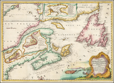
Seminal Map of New England & New York, Previously Owned By One of the Most Famous Collectors and Antique Map Authors of the 20th Century .
Decorative example of John Speed's map of the Northeast, from the 1676 edition of Speed's Prospect of the World, with a remarkable modern provenance.
On the verso of the map, the following annotation appears:
Frances Edwards
1953? GBP 6? (which would mean the map likely was purchased from RV Tooley)
Hung in Rodney Shirley's
shared study both years
at Harvard Business School
1954-1956
The map also includes the R.W.S. stamp used by Shirley on the verso. Rodney Shirley is the author of The Mapping of the World and numerous other cartographic reference books and is perhaps the most famous British Map Collector / Scholar of the second half of the 20th Century. R.V. Tooley is similarly the author of numerous reference works on the history of cartography and for many years was the primary map department employee at Francis Edwards in London.
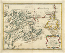
Speed's map is one of the earliest maps to illustrate dramatic shift from Dutch to English dominance in the Northeast, in the latter part of the 17th Century, and one of the earliest to use the term New York for both Manhattan (formerly New Amsterdam) and New York State, as well as one of the earliest appearances of New Iarsey (Jersey).
As noted by Michael Buehler, Speed's map shares the traits of many other regional maps of the period: a haphazard depiction of the St. Lawrence, no sign of Lake Ontario, Lake Champlain offset far to the East of its actual location, Cape Cod at essentially the same latitude as New York City, and the Delaware River curving eastward to connect with the Hudson. Many of these errors can be traced far back to early 17th-century prototype maps by Samuel Champlain, Adrien Block and others.
One of only a small group of English maps of New England, prior to 1700. Based on Jansson's map of 1651, it illustrates the territories acquired by the British with the capture of New Amsterdam in 1664, which radically adjusted the landscape of North American politics. While the map's geographical features are largely drawn from Jansson, the map's nomenclature is substantially anglicized, including the first appearance of name Boston (omitted from the Jansson maps), and the use of the names New York and Cape Cod.
The map is richly embellished with various animals in the interiior of the map, two compass roses, two cartouches and a coat of arms. Engraved by Francis Lamb after Speed's death, the map appeared in the 1676 edition of Speed's Prospect of the Most Famous Parts of the World, bearing the imprint of Bassett & Chiswell, and was also issued separately, beginning in 1675.
John Speed (1551 or '52 - 28 July 1629) was the best known English mapmaker of the Stuart period. Speed came to mapmaking late in life, producing his first maps in the 1590s and entering the trade in earnest when he was almost 60 years old.
John Speed's fame, which continues to this day, lies with two atlases, The Theatre of the Empire of Great Britaine (first published 1612), and the Prospect of the Most Famous Parts of the World (1627). While The Theatre ... started as solely a county atlas, it grew into an impressive world atlas with the inclusion of the Prospect in 1627. The plates for the atlas passed through many hands in the 17th century, and the book finally reached its apotheosis in 1676 when it was published by Thomas Bassett and Richard Chiswell, with a number of important maps added for the first time.