


|
||

|

|
|

|
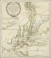
Fine old color example of Sayer & Bennett's rare battle plan of the area around New York City, depicting one of the most important early battles of the American Revolution.
Following the British evacuation of Boston and retreat to Halifax in March 1776, the Americans held a tenuous control of the East Coast from Maine to Georgia. The British control of the sea gave them the option to invade more or less when and where they wished, which they did, sending a vast force to take New York City and gaining control of the lower Hudson. This was one element of a grand pincer strategy, the other end of which was an attack by General Carleton from Montreal along the Lake Champlain - Lake George axis. The British sought to cut off New England and leave it essentially undefended. The British would then have been able to bring overwhelming force to bear on the northern colonies, after which it was anticipated the rest of the colonies would surrender.
Beginning in late June, 1776, the British began assembling in New York Bay, a large contingent of transports, warships, and troops. Uncertain of British plans and faced with the possibility of landings at any number of locations - on Long Island, on Manhattan itself, or possibly even upriver, Washington and the Continental Army could only dig in and wait. On August 22, 1776, the British landed a force of 15,000 regulars on the shore of Gravesend Bay in eastern Long Island (now Brooklyn). On August 26, 1776, Howe next sent two columns ahead to attack and occupy American forces encamped in lines stretching from the shore eastward along Gowanus Heights. This offensive was intended to disguise the main thrust, an "end run" through Jamaica Pass far to the east, which brought a large British force to bear on the left flank and rear of the Americans. The American left and center collapsed, with those who could retreating to fortifications at the village of Brooklyn on the East River.
Despite their success, the British failed to press their advantage, and on the night of August 29, 1776, Washington was able to extricate his trapped forces and ferry them across the East River to Manhattan. The British next attacked Manhattan itself on September 15, 1776. By mid-November, the batte was over and the British had captured Manhattan.
Published soon after the battle, the Sayer & Bennett plan documents the British landing and the Battle of Long Island up to and including the American retreat to Brooklyn. The map extends from Courtland on the Hudson in the north, to Sandy Hook and Middletown, New Jersey, in the south, depicting towns and settlements, major topographical features, and roads and residences. Major military positions and events of the Battle are shown, including the assembled British fleet and the Americans entrenched on Long Island and Manhattan, the initial British landing, and the diversionary thrusts and flanking maneuvers that routed the Continental Army.
Sayer and Bennett's plan states that it is "from the surveys of Major Holland." Samuel Holland was appointed Surveyor General of the Northern District of North America in 1764, and continued to serve in that capacity during the War. The map is almost certainly based on Major Holland's depiction of the region in his map, The Provinces of New York and New Jersey with part of Pensilvanie and the Governments of Trois Rivieres and Montreal, first published by Sayer & Jefferys in 1768 and reissued by Sayer and Bennett in 1775-76. This plan was probably intended to compete with William Faden's A Plan of New York Island with Part of Long Island, published just three days earlier. The much greater rarity of the Sayer and Bennett plan is due to its status as a separate issue, whereas the Faden was included in his North American Atlas, published in 1777.
Sayer & Bennett refers to the partnership of Robert Sayer (ca. 1724-1794) and John Bennett (fl. 1760-d.1787), which lasted between 1774 and 1783. Bennett had been Sayer’s apprentice. The pair specialized in American atlases, based on the work of Thomas Jefferys, who plates had been acquired by Sayer when Jefferys went bankrupt in 1766. They also began publishing navigational charts in the 1780s and quickly became the largest supplier of British charts in the trade. However, in 1783 Bennett lost control of his mental faculties and the partnership dissolved as a result. Sayer’s business was later passed to his employees, Robert Laurie and James Whittle.