


|
||

|

|
|

|
Fascinating regional / allegorical map of the eastern coast of America from the Carolinas to "Peru," with a disproportionately large Cuba and early plan of Havana, which was printed to illustrated the pirate exploits of Sir Francis Drake in the New World, beginning in 1586.
The map depicts the eastern coastline of America, with Florida at the center, Nova Francia (Carolinas) in the far north and Peru in the far south, with a disproporationately large image of the Island of Cuba and the harbor of Havana in the foreground. The view of Havana, albeit fanciful, is the earliest surviving view of the town.
This remarkable map illustrated the first edition of the very rare account of Drake's activities in Florida, the Carolinas and Caribbean, entitled Franciscus Dracus Redivivus . . . ( Sir Francis Drake Revived), which would later become the title of an important English work on Drake, published in 1626, by Philip Nichols. Published by Johann Clausen, the book espoused the virtues of Drake and Cavendish as champions of Protestantism in the struggle of the United Provinces and England against Spain. While the publisher's credit identifies Amsterdam, the text and map are in German and a number of German references identify the work as having been published in Cologne, while English language bibliographers also reference Amsterdam as the place of publication.
Published shortly after Sir Francis Drake's death in 1596, the full title of the book is:
Franciscus Dracus Redivivus: Das ist, kurze Beschreibung, aller vornehmbsten Reysen, Schiffarten vnnd Wasserschlachten, so der weitberümbte englische Admiral, Franciscus Dracus, welcher inn zwey Jahren vnd zehen Monaten orbem mundi beschiffet, hin vnd wider bey Pleymeuten, Cartsag: S. Domingo. August: Florida vnd der Insul Cuba, in seinem Leben glücklich gehalten vnd vollbracht. : Item von der jetzigen engelischen Admiraln vnnd Schiffobersten bey Calis Malis verrichten vnd Abzug, vnd was sie noch weiter daselbsten herumb biss dato vorhaben, [et]c. : Alles in drey Kupfferstück ordentlich vorgebildet, vnd durch Ziffern erkläret, [et]c,
The title suggests that the book reflects the Pirate exploits of Drake beginning with his voyage which commenced in Plymouth in November 1585, including time in Cartagena, Santa Domingo, St. Augustine, Florida and Cuba. On this voyage, Sir. Francis Drake struck first at Santiago (Cape Verde Islands), then arrived in Santo Domingo on January 1586, where he ransomed the city. He proceeded next to Cartagena, which he attacked on February 19, 1586. Drake then proceeded to the north, in search of Sir Walter Raleigh's Roanoke Colony in the modern day Carolinas, which at the time was in an area then called Nova Francia (as illustrated on the map). Drake's expedition first reached Cuba in April, 1586, before proceeding northward, coasting Florida in May 1586, where Drake attacked the Spanish fort and later the settlement of St. Augustine, seizing among other things a chest containing 2,000 gold ducats.
After leaving Florida, Drake proceeded north in search of the Roanoke Colony, passing Charleston Harbor before encountering the Colony on the Outer Banks of the modern North Carolina in June, 1586, before sailing for England, making landfall in Portsmouth on July 22, 1586.
The map, while crude in its construction and clearly derivative of the Baptista Boazio map entitled Civitas Carthagena, provides a template for Drake's time in the New World in 1586 and including a key which cross references his various encounters in the New World, beginning in Santa Domingo and the east coast of Cuba and ending in Florida (note 8) and Nova Francia (note 9), clearly a reference to the region which the French explorer Jean Ribault attempted to colonize on behalf of France in 1562
The John Carter Brown description of this work suggests that the work consists of a letter written by Thomas Cavendish, concerning the expeditions of Cavendish, Drake and Sir John Hawkins. The pamphlet consists of 11 pages, portraits of Drake and Cavendish, a view of the taking of Cadiz in 1596 and the present map.
The work is of the utmost rarity. The following passage appeared in the 1927 Annual Report-Brown University, John Carter Brown Library at page 5
The acquisition of books continues to be the adventure that the collecting of treasure has always been to those who give themselves to that thrilling employment. Just when it seems that everything worth while has been secured or has become no longer available for purchase, one of our friends among the booksellers turns up something of unusual interest. Or, when we have despaired of finding a much desired item- for example the fabulously rare Drake portrait needed for the Franciscus Dracus Redivivus, printed in German in 1596-a Parisian printseller appears on a casual visit and when facetiously questioned, reaches into his portfolio and answers the wild surmise in our eyes by drawing out the one print in all the world most essential to our happiness at that moment. The portrait was from the print collection of Louis Philippe, and the printseller, properly rewarded, is now searching for the Cavendish portrait, the Grosse Insel Cuba map and the Armada print needed to make our copy of the book, a great rarity in itself, the only one known to possess its plates besides that in the British Museum.
The map is a loose adaption of Boazio's map Civitas Carthagena in Indiae occidentalis continente sita, portu commodissimo ad mercaturam inter Hispaniam et Peru exercendam, published in Ledien in 1588 and engraved by Baptista Boazio. one of four charts drawn to accompany Walter Bigges' Expeditio Francisci Draki quitis Angli in Indias occidentales, the report of Drake's 1585 expedtion against Spain, published in 1588.
The map is of the utmost rarity and we know of no examples of the complete pamphlet or map to have changed hands in modern times. The only example of the map and pamphlet which we could locate in an American institution was at the John Carter Brown library. A copy of the pamphlet, lacking the map, was offered in the Harmsworth sale in 1949.
![[Pensacola] Plan de la Baye De Pansacola . . . 1744](https://storage.googleapis.com/raremaps/img/small/87767.jpg)
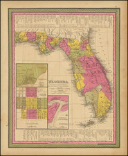
![County Map of Florida [with inset of Mobile]](https://storage.googleapis.com/raremaps/img/small/71379.jpg)