|
||

|

|
|

|
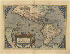
Unrecorded 1712 edition of Chiquet's map of North America from his Le Nouveau et Curieux…
While at first glance, this map is very similar to the 1719 Chiquet map recorded by McLaughlin, in fact, this is an entirely different plate. There are significant textual differences and an entirely different title cartouche.
There are a number of spelling errors in the 1719 edition of the map, which reflect an inaccurate transcription of the details from this map.
A link to the 1719 edition of the map can be found here: /gallery/detail/41728
The map includes a description of California in French text in the lower left corner and additional text and several ships and sea monsters in the Atlantic.
Very detailed throughout, with excellent example of California as an Island on the 2nd Sanson model and excellent detail in the Mississippi River Valley and Great Lakes regions. The interior parts of North America reflect the explorations of the Jesuits and the Spanish in the Southwest.
![A New Map of North America Shewing its Principal Divisions, Chief Cities, Townes, Rivers, Mountains &c. Dedicated to His Highness William Duke of Gloucester [California as an Island]](https://storage.googleapis.com/raremaps/img/small/100578.jpg)