|
||

|

|
|

|
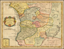
Fine Map of the West African Coastline From a Celebrated Voyage Collection
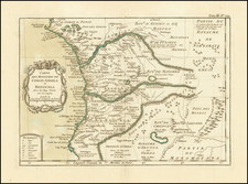
Detailed, striking map of the coasts of Sierra Leone, Liberia, and Guinea, from the Churchills' famous voyage collection, published in London in 1732. It is based on the voyage account of Jean Barbot, a French commercial agent.
The map shows the African coast from just south of the Cesto River in Liberia to the Sangareya Bay area of Guinea. The map is centered on the coastline of Sierra Leone, and includes the locations of what would become Freetown, Sierra Leone and Monrovia, Liberia. A large inset shows the Bay of Sierra Leone.
The inset and the coastline are both full of information for sailing vessels, including sounding depths, obstructions such as rocks and shoals, and sand bars. Such navigational information was important to European vessels who traded extensively with the coast for gold, textiles, and enslaved people. A few of these vessels are included in the waters off of Sierra Leone.
Inland, the names of tribes and African polities are scattered across the landscape. After the arrival of Europeans, led by the Portuguese, in the late fifteenth century, many of these groups began to trade extensively with the English, Dutch, Danish, Swedish, and other Europeans who established forts and trading posts along the coast. On this map, we can see an “Old Factory” near “English Road”, along with several villages that dot the coast.
While they might have traded with Europeans, many African peoples of this region also successfully resisted European incursions beyond the coast. They formed concentrated, powerful polities in the eighteenth and nineteenth century, confining European settlement to the coastal region until the end of the 1800s.
Jean Barbot
This map derived from the descriptions provided by Jean Barbot (1655-1712), a Frenchman. The French had begun to contest Portuguese trading on the Gold Coast in the 1530s; Barbot worked for the Compagnie du Sénégal. He went to Africa twice between 1678 and 1682, when he visited many of the forts along the coast.
A Huguenot, Barbot had to flee France after the 1685 Edict of Nantes, settling in England. He had finished a draft of his voyage account by 1688, but failed to find a publisher for the work. Instead, it only appeared in print in 1732, as part of the Churchill’s expanded voyage collection.
Barbot has long been used as a primary source of information about the Gold Coast. In recent decades, however, his account has been called into question by scholars. Comparisons of his work with other contemporary sources reveal that he relied on other African travelers as well, especially the Dutchman Olfert Dapper.
The Churchills’ voyage collection
The Churchill brothers, Awnsham (1658-1728) and John (ca. 1663-ca. 1714), were publishers in London who catered to an affluent clientele, and they were from a prominent family themselves. A distant relative was John Churchill, the Duke of Marlborough. Two of their older brothers, Joshua and William, served as Members of Parliament. Awnsham also was elected an MP for Dorcester in the first years of the eighteenth century.
In 1704, they released the first edition of one of their most successful works, A collection of voyages and travels: some now first printed from original manuscripts, others now first published in English. The collection consisted of four volumes of voyages and travel accounts derived from primary sources in English, French, Dutch, Italian, Spanish, and German, a feat not seen since Hakluyt’s work over a century earlier.
The Churchill brothers are perhaps best-known today as the publisher of the works of John Locke. Awnsham supported religious tolerance and moderation for nonconformists, stances that would have appealed to Locke. Locke is supposed to have written the introductory discourse which opens the voyage collection.
This map appeared in the 1732 expanded edition, which extended the collection to six volumes. Barbot’s Description of the Coasts of North and South Guinea featured in the fifth volume. A further edition of eight volumes was issued in 1752.
The collection was widely respected and considered one of the most prestigious examples of the genre in the eighteenth century. The maps and illustrations from the collection are relatively scarce on the market, especially given how important the publication was when it debuted.
Johannes Kip (1653-1722) was a topographical engraver. Born in the Netherlands, he had immigrated to England by 1690. His most famous work are the engravings of country houses in Britannia Illustrata (1707), which he produced with Leonard Knyff. He also contributed to the 1732 expanded edition of the Churchill brothers voyage collection.