


|
||

|

|
|

|
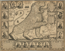
Rare decorative Leo Belgicus Map with numerous portraits, first published by Visscher in 1641, shortly before the death of the Spanish Archduke Cardinal-Infante Ferdinand (Governor of the Low Countries from 1634-1641), pictured in the upper left corner.
The Leo Belgicus and Leo Hollandicus series of maps began in the late 16th Century as a symbol of the strength and bravery of the Low Countries. Emblematic of the Low Countries struggles during the Eighty Years' War or "Dutch War of Independence" (1566-1648), the Leo maps symbolized the revolt of the Low Countries against the Spanish (Habsburg) Empire.
The year of 1641 was a significant point in "Dutch War of Independence". On July 27th 1641, Frederick Hendrik captured the town of Gennep in the provence of Geldern. In the same year general peace negotiations were initiated in the catholic city of Munster, and the prostestant city of Osnabruck, including the main participants in the Thirty Years' War: France, Sweden, Spain, the Emperor and the Republic. Though not formally recognized as an independent state, the Dutch republic was for the first time allowed to participate in these peace negotiations. The drafting of the instructions for the Dutch delegation occasioned spirited debate. Holland made sure that it was not barred from their formulation. The Dutch demands eventually agreed upon were: cession by Spain of the entire Meierij district; recognition of Dutch conquests in the Indies (both East and West); permanent closure of the Scheldt to Antwerp commerce; tariff concessions in the Flemish ports; and lifting of the Spanish trade embargoes.
The war continued until 1648 with the Peace of Munster and the Dutch Republic was officially recognised as an independent country.
The present example is an updated version of the Leo Belgicus map engraved by Johann Van Deutecum and first issued in 1598, with a second state published by Henricus Hondius of Den Hague in 1630.. Claes Jansz. Visscher acquired the copperplate from Henricus Hondius in or about 1641. The events of 1641 likely inspired Claes Jansz. Visscher to update the Hondius Leo map, most notably by adding two medallions portraits to the plate of the contemporary rulers and negotiators Prince Frederik Hendrik of Orange (Stadholder 1625-1647) and the Spanish Archduke Cardinal-Infante Ferdinand (Governor of the Low Countries from 1634-1641).
As Ferdinand died on 9th November 1641, it would seem most likely that the changes to the plate were made in or before November 1641. Visscher updated the map by adding the date of 1650.
States of the Map and Rarity
- State 1 (1598): 2 copies are recorded
- State 2 (1630): 2 copies recorded. The coat of arms of England is updated. Although Prince Maurice and the Archduke Albert had already died, the captions below their medallions remained unchanged. -
- State 3 (1641): C.J. Visscher imprint, dated added. Two medallion portraits added showing Archduke Ferdinand and Prince Frederik Hendrik of Orange. The base below the lion is hatched. The last lines of the Dutch text now read : (…) ende hooggeborene Ferdinandus Infans Cardinael en de Edelen en meer dan Martium Frederik Hendrick die beyde tegenwoordelick regiere. (unrecorded, sold at auction in January 2016)
- State 4 (1650): C.J. Visscher, dated 1650, 8 examples are located by van der Heijden and prof. Schilder and recently one other example sold at Sotheby's. London, 9th May, 1212, lot 47.
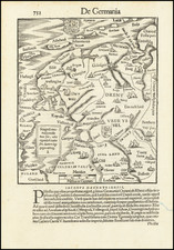
![[Course of the Rhine River] Nova Tractus Totius Rheni Oder Neue beschreibung des Rhein-Strom](https://storage.googleapis.com/raremaps/img/small/58670.jpg)
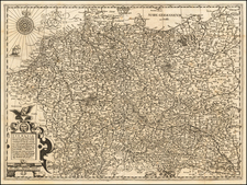
![[ Holy Roman Empire ] A Newe Mape of Germany Newly Augmented by Iohn Speed Ano Dom: 1626](https://storage.googleapis.com/raremaps/img/small/68482.jpg)
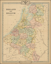
![[Amsterdam] Amstelredamum, Nobile Inferioris Germaniae Oppidum](https://storage.googleapis.com/raremaps/img/small/96920.jpg)