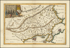


|
||

|

|
|

|
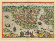
Important early map / birdseye view of Istanbul, from Braun & Hogenberg's monumental town book.
The Braun & Hogenberg view is one of the finest and most sought-after views of Istanbul. Viewed from the village of Scutari, the City is shown with all its fortifications, the original Genouse district of Galata on the opposite bank of the Golden Horn to the right. European galleons and Turkish galleys fill the seas of the Bosporus and Golden Horn. The great buildings of the 16th Century Istanbul during the reign of Suleiman the Magnificent can be clearly seen, including the "Suleymaniye Mosque" and the "Topkapi" palace. The lower center is filled with a parading Turkish horseman and troop of Janissaries.
This is the second state of the view, with the roundel at the right including the portrait of Sultan Murad III. In the first state, the roundel is blank.
The following is excerpted from the work of Julian M. Stargardt and his essay on the view:
The original of this map is often incorrectly attributed to Giovanni Andrea Vavassore, called Vadagnino, who created a fine view of Constantinople published in Venice in 1520. Vavassore's view is also said to have influenced the view published in the 1550 and subsequent editions of Sebastian Munster's Cosmographia. Vavassore's view is in turn said to have been based on a 1480 view, now apparently lost, by Venetian artist Giovianni Bellini, who was invited by Mehmet II Fatih, i.e. 'the Conqueror' to Constantinople.
But a closer comparison of the Vavassore, Munster, and Braun & Hogenberg maps or views of Constantinople reveals significant differences. Most notably in the topographic details of the city-scape, especially the Roman remains such as the Hippodrome, today's 'At Meydan', which while not absent in the Vavassore map, is not clearly depicted, whereas it is very clear, detailed and accurate in both the Munster and Braun & Hogenberg maps, as are the locations of churches, palaces and other monuments which are more accurately depicted in the Munster and Braun & Hogenberg maps.
Compared with the Munster map, the Braun and Hogenberg map or view of Constantinople is in particular distinguished and made unique by the portrait of the mounted horseman identified as the Ottoman ruler Suleiman the Magnificent (6 November 1494 - 7 September 1566) who claimed among other titles to be Roman Emperor, a title which even the Holy Roman Emperor Charles V was forced to recognize in 1547.
In his essay Stargardt puts forth evidence that "the title of the map 'Byzantium Nunc Constantinopolis' may be a part of Habsuburg anti-Ottoman propaganda. He notes that the origins of the name Byzantium can be found in mythology.
Byzas decided to set sail with his companions to found a colony but before departing he consulted the Oracle at Delphi who gave him the enigmatic advice "Found your colony opposite the land of the blind". He set sail for the Black Sea intending to join the burgeoning Greek colonies there. But, as he came to the Sea of Marmara entrance to the Bosphorus, he glanced at the flourishing settlement of Chalcedon, today's Kadikoy, on the Asian shore and then across to the European shore where he was struck by the magnificent but uninhabited (by humans at any rate) triangular peninsular pointing at Asia with its family links to his mother and grandmother. To Byzas it seemed clear the settlers of Chalcedon were blind for ignoring the magnificent European location and Byzas decided to found his colony on that spot.
Whatever the truth of these charming legends, the city and state of Byzantium grew from its mythical 6th century BC roots into a rich and flourishing trading state that by at least the 1st century BC had taken the star and crescent moon as its emblem. It remained independent until 196 AD, when it was conquered by Roman forces loyal to Septimus Severus, after having allied itself with the losing side in one of Rome's frequent civil wars. The city suffered in the siege that led to its capture but Severus caused it to be re-built and it continued as an important Roman city. Its highly defensible and strategic location astride maritime and land trade routes from East to West and North to South attracted Constantine the Great and he chose it to replace Rome as the Imperial capital.
Re-dedicated as Constantinople on 11 May 330 AD, a name it was to keep for the next 1,600 years, the new capital of the Roman Empire was self-consciously a Christian city, as opposed to pagan Rome which continued to host pagan traditions in its city government until the late 4th century AD. Constantinople's two principal churches, Hagia Irene and Hagia Sophia, both illustrated on this map and both still standing today, are dedicated to 'Sacred Peace' and 'Sacred Wisdom', reflecting the aspirations of the new imperial capital and the new official Christian religion of the Roman Empire.
Constantine the Great encouraged leading Roman families to resettle in Constantinople, and the transfer of wealth and power to Constantinople was reflected in the ascendancy of the city as the new imperial capital over Rome. An ascendancy reinforced when Rome was sacked by invading "barbarians" while Constantinople was not. Though Constantinople was firmly located within the Greek speaking sphere of the Roman Empire, the Court and administrative language continued to be Latin until in or about 620 AD when, according to the later Emperor Constantine VII Porphyrogennetos, the Emperor Heraclius decreed that Greek would replace Latin as the official language for military and administrative purposes. To suggest to a Latin speaking Roman Emperor like Justinian that either the city he ruled from or his empire was "Byzantine" would, one imagines, not have been greeted favorably. The city of Rome was a hollow shadow of its former glory and glad to accept protection from Justinian and his successors. For the Romans who ruled from Constantinople until Tuesday 29 May 1453, the city was Constantinople and their realm was Roman and that is how their contemporaries, friends or foes, around the world referred to them.
Until the late 16th century the names "Rome", "Roman" and "Roman Empire" were the accepted names for the Roman Republic, the Roman Empire and what today is generally called the 'Byzantine Empire'. The division of the Roman Empire and the Byzantine Empire is an anachronism with its roots in 16th Century Habsburg anti-Ottoman propaganda. Prior to 1557, "Rome", "Roman Republic" and "Roman Empire" were the accepted names for the geo-political entity that had its mythical origins with Romulus and Remus on or about 21 April 735 BC, with the founding of the city of Rome in Latium, today's Lazio in Italy. Such was the majesty and longevity of the Roman Empire that its name continued to be used to invoke legitimacy long after the Roman Empire's effective demise as a geo-political entity. In the 15th and 16th Century, and to a lesser extent later, the name of Rome was a political hot potato and potent propaganda symbol, particularly in the long running wars between the Habsburgs and the Ottomans. Both sides claimed to be the true heirs of Rome as they struggled for military and political dominance in Europe. To many people today it is strange to reflect that Ottoman Turkey's European borders extended almost to Venice as recently as the late 19th century while its Asian borders extended almost to the Indian Ocean. Braun and Hogenberg's map "Byzantium Nunc Constantinopolis" may be part of the Habsburg's propaganda campaign to detach the name "Rome" from the Ottomans. To contemporaries, the name of the city was "Constantinople" as it had been for the previous 1,242 years and was to remain for the next 358 years, until the Turkish Postal Law of 28 March, 1930 officially changed the name to Istanbul, itself a vernacular contraction derived from the Greek "eis tin polis" ('in' or 'going to the city', i.e. "The City"). In 1572 only a few scholars would have recalled that the city had once been called Byzantium.
* * *
The term "Byzantine" for the Roman empire was first used in 1557 by the Habsburg scholar-librarian Hieronymus Wolf based in Augsburg, the imperial capital of the Holy Roman Empire. Wolf was sponsored by the powerful Fugger banking family whose close ties to the Habsburg dynasty were legendary and whose library was said to be the best in Europe. Wolf uses the name "Byzantine" to identify the latter Roman Empire in his 1557 Corpus Historiae Byzantinae. It seems likely that Wolf consciously used the term Byzantine as a piece of Habsburg anti-Ottoman propaganda at the height of Habsburg-Ottoman rivalry and at a time when the Ottomans were claiming to be the true heirs of Rome, perhaps as a way of legitimizing and making more attractive their rule over a large and, at the time, increasing part of Central, Southern and Eastern Europe. A scant 10 years earlier the Holy Roman Emperor Charles V's ambassadors on behalf of the Holy Roman Empire had been obliged to sign a truce with the Ottomans, the 1547 Truce of Adrianople, in which the Holy Roman Emperor Charles V is identified not as "Holy Roman Emperor" but as "King of Spain", while the Ottoman Emperor, Suleiman the Magnificent, is identified as 'Roman Emperor'. Under the terms of the truce, the Habsburgs recognized Ottoman control of Hungary, did homage to the Ottomans as the Habsburg's overlords in Hungary and paid the Ottomans an annual feudal homage of 30,000 gold ducats for their lands in Hungary. One can almost hear Charles V's teeth gnashing and grinding at the humiliation. These terms were again formalized in the 1568 Treaty of Adrianople. In some senses, though it may seem surprising today, the Ottomans had as good or better claim to call themselves "Roman" as the Habsburgs. The Ottomans were by inter-marriage descended from Roman imperial dynasties, they had conquered much of the former Roman empire, including in 1453 its capital Constantinople, and had absorbed imperial Roman noble families into their society, they believed themselves, or at least held themselves out, to be Rome's heirs as they vied with the Habsburgs for control of the Mediterranean basin.
With the coming of the Reformation the contest became more complex as the Ottomans, in sharp contrast to some so-called Christian nations of the time, practiced religious tolerance and gave safe haven to refugees from political and religious persecution, like the Jews from Spain, or Protestants and Orthodox from Bohemia and Hungary, or Catholics from newly Protestant realms. To the Habsburgs, it must have looked like a life-and-death challenge with the Ottoman super-power whose borders stretched from Venice to Persia, threatening to cut Austria off from the sea, and who besieged Vienna itself in 1521. Little wonder then that Habsburg propagandists seized on whatever material they could to undermine Ottoman legitimacy and strived to undermine Ottoman claims to be heirs to Rome and the Roman Empire.
* * *
It took until the latter 19th century before acceptance was achieved of the names "Byzantine" and "Byzantium" for the Roman Empire. Gibbon in his seminal "Decline and Fall of the Roman Empire" continued to use "Rome" and "Roman", not "Byzantine" or "Byzantium". Though in the latter 19th century the terms Byzantine / Byzantium came to replace Rome and Roman for the latter Roman Empire, to this day debate continues among scholars of the subject as to when to date the "founding" of the Byzantine Empire. The truth is there never was an empire by that name and its leaders and citizens would be enraged or perhaps laugh if they heard their home referred to that way.
The rise in popularity of the terms Byzantine / Byzantium for the latter or Eastern Roman Empire can be traced through the use of the terms by authors such as French author Charles du Fresne Sieur du Cagne (1610-1688) wrote "Historia Byzantina" published in 1680 in Paris by Louis Billaine, which affected the likes of influential French philosopher Montesquieu. In English it was not until George Finlay's (1799-1875) "History of the Byzantine Empire from 716 to 1057" (1857) that the term and concept of a Byzantine Empire came into English use. Subsequent scholars have adopted the use of the terms "Byzantine" and "Byzantium" to identify and distinguish the latter Eastern Roman Empire from the earlier empire.
Tying this historical overview back to the view, Stargardt notes:
And thus back to Braun and Hogenberg's beautiful map of Constantinople. Georg Braun was the principal editor of Civitates Orbis Terrarium published between 1572 and 1617, from which the current map comes. . . Braun was a Catholic priest, and Frans Hogenberg was also a Catholic, who to avoid persecution fled his native Mechelen (in today's Belgium) and settled in 1564 in Cologne. Thus both would most likely have been partisans of the Habsburg cause against the Ottomans and taken the opportunity to promote the use of the term "Byzantium" in place of Constantiniople, though at least so far as the name of the city is concerned there is some historical validity to the name, it was known as Byzantium before it was rebuilt, expanded and renamed between 324 and 330 AD.
Georg Braun (1541-1622) was born and died in Cologne. His primary vocation was as Catholic cleric; he spent thirty-seven years as canon and dean at the church St. Maria ad Gradus, in Cologne. Braun was the chief editor of the Civitates orbis terrarum, the greatest book of town views ever published. His job entailed hiring artists, acquiring source material for the maps and views, and writing the text. In this role, he was assisted by Abraham Ortelius. Braun lived into his 80s, and he was the only member of the original team to witness the publication of the sixth volume in 1617.
Frans Hogenberg (ca. 1540-ca. 1590) was a Flemish and German engraver and mapmaker who also painted. He was born in Mechelen, south of Antwerp, the son of wood engraver and etcher Nicolas Hogenberg. Together with his father, brother (Remigius), uncle, and cousins, Frans was one member of a prominent artistic family in the Netherlands.
During the 1550s, Frans worked in Antwerp with the famous mapmaker Abraham Ortelius. There, he engraved the maps for Ortelius’ groundbreaking first atlas, published in Antwerp in 1570, along with Johannes van Deotecum and Ambrosius and Ferdinand Arsenius. It is suspected he engraved the title page as well. Later, Ortelius supported Hogenberg with information for a different project, the Civitates orbis terrarium (edited by Georg Braun, engraved by Hogenberg, published in six volumes, Cologne, 1572-1617). Hogenberg engraved the majority of the work’s 546 prospects and views.
It is possible that Frans spent some time in England while fleeing from religious persecution, but he was living and working in Cologne by 1580. That is the city where he died around 1590. In addition to his maps, he is known for his historical allegories and portraits. His brother, Remigius, also went on to some fame as an engraver, and he died around the same time as his brother.
![[Persia and the Middle East]](https://storage.googleapis.com/raremaps/img/small/63394kb.jpg)