|
||

|

|
|

|
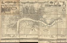
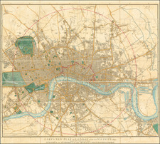
Fine map showing several proposals for improvements of the commercial navigation and exploitation of the Thames River in London, published in the Parliamentary Papers in 1796.
The map highlights the proposals for modifications to the docks at Wapping and Thames commercial navigation by two of the most respected engineers who submitted proposals on the project, Ralph Walker and Graeme Spence. The two plans highlight the two different schools of thought on how to improve commercial navigation on the Thames in London, with Spence proposing an orderly reorganization of the dock system, while Walker's map sets out a more elaborate system involving canals on the north side of the Thames at Wapping and the Isle of Dogs.
The present example also includes a volvelle entitled A Perpetual Tide Table for Blackwall, Shewing the Moon's Changing &c. with the times of high water & the height that each tide will rise to in feet & inches there at at Pelican Stairs. By Ralph Walker NB New Moon 7th April 1796, which is pasted onto the map at lower bend in the Thames.
Improved navigation on the Thames River was an issue that was much debated between 1793 and 1795. There were two significant camps, one which favored maintaining the existing commercial trading points on the river and one which favored the creation of canals, in order to "obviate the great circuity and the shallowness of the river in certain places. The so-called Commissioners of the Thames Navigation, consisting primarily of land owners, opposed the canal concept, while the commercial community of London and various larger neighboring towns favored canals.
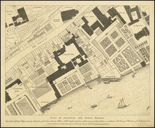
The plan of "Mr. Spence" was described in the History of the Port of London by Sir. Joseph G. Brookbank, as follows:
The plan of Mr. Spence, Maritime Surveyor to the Admiralty, proposed an arrangement and division of trades and shipping into twelve classes, each class to have a separate dock proportionate to the frequency and number of arrivals. Six of the docks were to be 600 feet square and to be situated on the north side of the river between the Tower and Limehouse. The other six were to be 400 feet square on the opposite shore. As an alternative, Mr. Spence suggested that all twelve docks should be placed on the shore of the Isle of Dogs, opposite Deptford and Greenwich. No witnesses, except Mr. Spence himself, appeared in favour of his scheme. The brethren of the Trinity House, to whom it was referred, declared its immediate practicability and praised its ingenuity, but stated a preference for one capacious dock as less expensive and more generally convenient. Its cost was estimated at £510,000.
Brookbank described Walker's proposal as follows:
Mr. Walker's plan for docks was to cost £880,000. Mr. Walker was a captain in the West India trade. He proposed docks at Wapping nearly on the site of those intended by the merchants, with an area of fifty-five acres of water and spacious wharves, but without warehouses. Two entrances from the dock were proposed, with a third into a canal similar to that suggested by the merchants, but occupying ground nearer the river. Another dock for timber ships was designed to be made across the Isle of Dogs. This scheme met with the unqualified approbation of the Trinity House Brethren.
The larger map features the work of Ralph Walker, a civil engineer whose work on Thames related navigation projects would make him one of the most important civil engineers addressing the issue in the late 18th and early 19th Centuries. Ralph Walker (1749-1824), a Civil Engineer, started his career as a Captain of a West India ship, before settling as a planter in Jamaica. Walker designed an improved mariner's compass while in Jamaica, which led to his being encouraged to return to England by the British Admiralty. Upon his return, the proposal for a system of wet docs on the Thames was under discussion and in 1796 Walker submitted his proposals, which incorporated the forerunner of the City Canal across the Isle of Dogs.
Walker submitted designs for the City Canal in 1796 as part of his preliminary designs for the West India Docks on the Isle of Dogs, eventually being appointed resident engineer in August 1799, supervised by William Jessop. In 1800, he submitted designs for a cast iron twin leaf swing bridge as part of the Docks scheme. In October 1802, however, Ralph Walker had a professional disagreement with Jessop and resigned his post on the West India Docks. He remained on good terms with Jessop, working on a scheme to remove the Blackwall Rock obstruction off Blackwall Point in the River Thames. In 1803, he was appointed engineer to the East India Docks Company, working with John Rennie. In 1807 the Surrey Commercial Docks Company was formed with Ralph Walker as engineer (until 1810), and James superintending the new lock and keeping the accounts. Ralph Walker was appointed engineer to the East London Waterworks Company from August 1807 to 1824. He designed and supervised the construction of the original Old Ford works along with two low level reservoirs and an upper distribution reservoir. Walker also designed a water supply scheme for Portsmouth, and was consulted on designs for Dover harbour, and on the Thames and Medway Canal scheme.
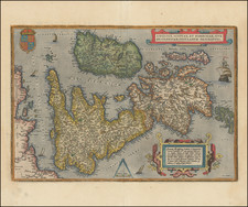
Graeme Spence (1758-1812) was a maritime surveyor employed by the British Admiralty. Spence surveyed large parts of the British coast and ports and the West India Docks in London. In 1789, he was charged by the Admiralty with surveying the Isles of Scilly, completing his work in 1792. He later acted as pilot to Lord Nelson on HMS Medusa. Spence invented many instruments and survey apparatus, several of which were used by the Royal Navy.
A nautical description and survey of the Scilly Isles taken 1790-1792 by Graeme Spence, made by order of the Admiralty, 158 folios: (p. 1) explanatory introduction; (p. 1) geographical description; (p. 13) nautical description; (p. 109) account of the tides followed by tide-tables.
The map in its present form is quite scarce, with a variant of the Volvelle included on this example, which is a different printing than the example in the National Maritime Museum Collection: collections.rmg.co.uk/collections/objects/540436.html
![[British Isles]](https://storage.googleapis.com/raremaps/img/small/72007.jpg)