|
||

|

|
|

|
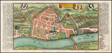
Rare early map of Switzerland.
The map extends from Basel in the north to the Italian Lake District in the south.
A search of various references suggests that the map is most likely by Tassin. See Fascikel IIa., Landesvermesung und Karten der Scweiz, ihrer Landstriche unde Kantone. Herausgegeben vom Eidgenossischen topographischen Bureau . . . Bern, 1892 (p. 30 and p. 43). See also Broer Map collection. Ryh 3202 : 16 (illustrated, dating map at 1668).
We have found references to this map suggesting it might also be attributable to Berey or Langlois, although Tassin seems the most probable.
Nicolas Tassin (fl. 1633-55) was appointed 'royal cartographer' at Dijon before setting up as an engraver in Paris where he issued various collections of small maps and plans of France, Switzerland, Germany and Spain. Tassin first published his maps in his own atlas Cartes Generale de Toutes Les Provinces de France in 1634, with an enlarged second edition in 1637 (France, royaumes et provinces d'Europe).
![(First state!) Lacus Constantiensis XX Tab Nova [The Bodensee]](https://storage.googleapis.com/raremaps/img/small/94703.jpg)
![Gallia Narbonens [on sheet with] Savaudiae Ducat. [on sheet with] Venuxini Comitatus Descr.](https://storage.googleapis.com/raremaps/img/small/61471.jpg)