|
||

|

|
|

|
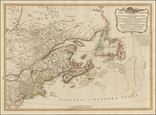
Exceptionally detailed Revolutionary War Plan of Narranganset Bay, prepared by the French Depot De La Marine, specifically for use by French vessels, during the time of their alliance with America during the American Revolution.
This fine plan of Narraganset Bay was one of a group of maps and sea charts immediately sent "to the Marquis de Chabert at Brest, in January, 1781, shortly prior to his departure with Admiral de Grasse, for the North American campaign. Their voyages would end in the victorious battle at Yorktown in Chesapeake Bay. The [charts were] also being used for strategic planning in Paris. . . the Depot de la Marine also provided it to at least one American. . . Benjamin Franklin . . . ." (Pedley, The Commerce of Cartography..., p 152).
The map is based upon Charles Blaskowitz's Topographical Chart of the Bay of Narraganset in the Province of New England, first published in 1777, the most important eighteenth-century chart of Narraganset Bay. Nebenzahl notes that "it is certain that the British, after occupying Newport at the end of 1776, used this map for their operations in this pivotal area. The detail shown is remarkable, including even the names of farmers on their land locations."
Blaskowitz arrived in America in the early 1760s, where he began surveying work in upstate New York and along the St. Lawrence River. In March 1764, he was commissioned as part of Samuel Holland's North American Survey team and would eventually become Holland's Deputy Surveyor by 1775. Blaskowitz's first assignment was to survey Aquidneck Island and Narragansett Bay in Rhode Island, in order to determine whether Newport would be a suitable location for a naval base. Blaskowitz completed this survey in 1764. Blaskowitz re-surveyed the region as part of Holland's larger surveys of the coast in 1774, for the Board on Trade and Plantations.
The colonies were already on the brink of Revolution and Newport was a hotbed of insurrection. In 1772, British naval ships laid siege to Narragansett Bay, in order to enforce customs duties on incoming vessels. After months of antagonizing the city's merchants, the much-hated British captain of the HMS Gaspee, was murdered and the ship burned. The region instantly became a point of great interest in Great Britain, with the King offering a reward for the capture of the insurrectionists. In May 1776, Rhode Island became the first Colony to declare its independence and the British would occupy Newport from November of 1776, until the end of August 1778.
The map itself is unusual in that it is a combination of a nautical chart and topographical map (and hence the title, "A Topographical Chart..."). The Bay is clearly shown with its many islands and intricate inlets, with numerous soundings which give accurate readings of the treacherous waters. On the shore, impressive detail is depicted, with individual farms named and elegant hachuring showing elevations. Eight batteries are shown via lettered references, with a key at the top right corner which details the numbers and types of canons. Along the right side of the map are the names of the principal land owners of the region, along with a brief description of the area. A large and well-designed dedication by Faden, to Lord Percy, appears just below.
Blaskowitz's surveys would be used for two printed charts, by Des Barres and Faden, respectively. The Faden chart was a much more accomplished production, on a larger sheet and more elaborately engraved (and according to Pedley, costing two and a half times as much at the time of publication). The map was sold separately, as this sectioned case map copy, or within some copies of Faden's North American Atlas. The present example is Sartine's copy of the Blaskowitz map, prepared for use by the French Navy, during the Revolution.
The Dépôt de la Marine, known more formally as the Dépôt des cartes et plans de la Marine, was the central charting institution of France. The centralization of hydrography in France began in earnest when Jean-Baptiste Colbert became First Minister of France in 1661. Under his watch, the first Royal School of Hydrography began operating, as did the first survey of France’s coasts (1670-1689). In 1680, Colbert consolidated various collections of charts and memoirs into a single assemblage, forming the core of sources for what would become the Dépôt.
The Dépôt itself began as the central deposit of charts for the French Navy. In 1720, the Navy consolidated its collection with those government materials covering the colonies, creating a single large repository of navigation. By 1737, the Dépôt was creating its own original charts and, from 1750, they participated in scientific expeditions to determine the accurate calculation of longitude.
In 1773, the Dépôt received a monopoly over the composition, production, and distribution of navigational materials, solidifying their place as the main producer of geographic knowledge in France. Dépôt-approved charts were distributed to official warehouses in port cities and sold by authorized merchants. The charts were of the highest quality, as many of France’s premier mapmakers worked at the Dépôt in the eighteenth century, including Philippe Bauche, Jacques-Nicolas Bellin, Rigobert Bonne, Jean Nicolas Buache, and Charles-François Beautemps-Beaupré.
The Dépôt continued to operate until 1886, when it became the Naval Hydrographic Service. In 1971, it changed names again, this time to the Naval and Oceanographic Service (SHOM). Although its name has changed, its purpose is largely the same, to provide high quality cartographic and scientific information to the France’s Navy and merchant marine.
![[ New England / Northeast / Canada ] Tierra Nueva](https://storage.googleapis.com/raremaps/img/small/86737.jpg)
![[British Colonies in America] Carte Qui Contient Une Description Des Iles & Terres Que Les Anglois . . .[maps of Chesapeake, Carolinas, New England, Bermuda, Gulf Coast, Jamaica, Barbadoes & Canada]](https://storage.googleapis.com/raremaps/img/small/61480.jpg)
![A New and Exact Map of the Dominions of the King of Great Britain on ye Continent of North America . . . [Beaver map]](https://storage.googleapis.com/raremaps/img/small/101277.jpg)