|
||

|

|
|

|
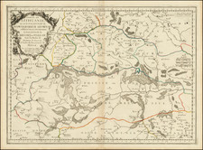
Fine early plan of St. Petersburg, published in London.
This fine plan shows St. Petersburg after the initial phases of its construction had been completed. In 1703, the site, at the head of the Gulf of Finland, was selected by Czar Peter the Great to be the place on which a new capital city for the Russian Empire was to be built. Peter pressed a massive labor force of serfs to build the city, and no expense was spared. Leading architects and artisans from across Europe were offered large salaries to dedicate themselves to the task. The overall project came to be overseen by the French landscape architect, Jean-Baptiste Alexandre Le Blonde, who had previously served Louis XIV, who was ably assisted by the Swiss architect, Domenico Trezzini.
As shown much of the city was layed out on Vasilyevsky Island, that lay within the mouth of the Neva River. As shown, the island was bisected by a series of streets that follow a rational grid, which in places were to contain massive squares. On the south bank was the Admiralty district and on an island on the north bank, above Vasilyevsky Island, was the St. Peter & Paul Fortress. One might remark that much of the city resembles a series of gardens, and this is, in good part, due to the fact that Le Blonde's signature passion was designing gardens.
In spite of the massive resources thrown at the project, the original Le Blonde-Trezzini Plan was altered as work progressed. Vasilyevsky Island was proven to be too low-lying and prone to flooding to permit the creation of the canals, nor was it viewed appropriate as the site of the main town. While the area would progressively be built-up as the 18th Century progressed, with streets largely following the lines of the proposed grid of canals, the main part of the city was built in the area which lay to the south of the Neva.
Thomas Kitchin was a British cartographer and engraver. Born in Southwark, England, Kitchin was the eldest of several children. He was apprenticed to the map engraver Emanuel Bowen from 1732 to 1739, and he married Bowen’s daughter, Sarah, in December 1739. By 1741 Kitchin was working independently and in 1746 he began taking on apprentices at his firm. His son Thomas Bowen Kitchin was apprenticed to him starting in 1754. By 1755 Kitchin was established in Holborn Hill, where his firm produced all kinds of engraved materials, including portraits and caricatures. He married his second wife, Jane, in 1762. Beginning in 1773 Kitchin was referred to as Hydrographer to the King, a position his son also later held. He retired to St. Albans and continued making maps until the end of his life.
A prolific engraver known for his technical facility, clean lettering, and impressive etched decorations, Kitchin produced several important works throughout his career. He produced John Elphinstone’s map of Scotland in 1746, and the first pocket atlas of Scotland, Geographia Scotiae, in 1748/1749. He co-published The Small English Atlas in 1749 with another of Bowen’s apprentices, Thomas Jefferys. He produced The Large English Atlas serially with Emanuel Bowen from 1749 to 1760. The latter was the most important county atlas since the Elizabethan era, and the first real attempt to cover the whole country at a large scale. In 1755 Kitchin engraved the important John Mitchell map of North America, which was used at the peace treaties of Paris and Versailles. In 1770 he produced the twelve-sheet road map England and Wales and in 1769–70 he produced Bernhard Ratzer’s plans of New York. In 1783, he published The Traveller’s Guide through England and Wales.
![Повстанцы 1863 Года [(Polish) Insurgents of 1863]](https://storage.googleapis.com/raremaps/img/small/52719.jpg)
![[Hydrographic Map of European Russia] ГИДРОГРАФИЧЕСКАЯ КАРТА ЕВРОПЕЙСКОЙ РОССИИ](https://storage.googleapis.com/raremaps/img/small/54482.jpg)
![[ Baltic, Poland, Ukraine, Russia ] Tabula VIII Europe (title on verso)](https://storage.googleapis.com/raremaps/img/small/50926.jpg)
![[ St. Peterburg ] Plan de St. Petersbourg et de ses environs relatif au Memoire, concernant les moyens de mettre cette ville a l'agbri des inondations et d'etablir deux grands ports, dessine d'apres des cartes exactes, par le chevalier de Wiebeking, conseiller prive de S.M. le Roy de Baviere, etc. (With separately published Legende du Plan De St.-Petersbourg . . . )](https://storage.googleapis.com/raremaps/img/small/64539.jpg)