|
||

|

|
|

|
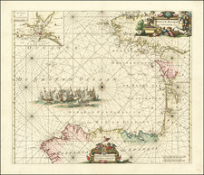
Rare sheet of coastal profiles showing a set of views along the north coast of Spain, originally from a Danish sea atlas that details the Spanish and Portuguese coasts. Eleven separate coastal views are presented, the top of which shows a view of the mountainous region in the immediate vicinity of the San Sebastian inlet.
The views are extremely detailed and show the imposing mountains and coastlines of northern Spain. Due to the harshness of the coastline, most cities in the region started in protected inlets and bays, and are thus not immediately visible from the ocean. As such, charts such as these would have been invaluable in navigating the area. Other cities referred to include Santander and Santoña, neither of which is visible from the open ocean.
The present set of charts appears in a very rare Danish work, which is titled "Samling af Kaart over Havne og Ankerpladse, tilligemed Fæstninger, henhørende til Beskrivelsen over den spanske og portugisisske Kyst" (Collection of Map of Ports and Anchor Plates, as well as Fences, belonging to the description of the Spanish and Portuguese Coast).
![(City Views - World and Iberian Peninsula) Illustriorum Hispaniae Urbium Tabulae, cum Appendice Celebriorum Alibi aut olim aut nunc Parentium HIspanis, Aut euroum Civitatum Commerciis florentium. [Maps of the Most Famous Cities in Spain, with an Appendix of Other Notable Cities, Either Formerly or Currently Associated with Spain, or Prominent in the Trade of European Cities.]](https://storage.googleapis.com/raremaps/img/small/94019.jpg)
![[Sevilla / Seville] Plano Parcial de la Ciudad de Sevilla - 1964](https://storage.googleapis.com/raremaps/img/small/68025.jpg)
![[ Galicia ] Gallaecia Regnum descripta a F.Fer. Oja Ord Pred.](https://storage.googleapis.com/raremaps/img/small/79693.jpg)