|
||

|

|
|

|
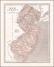
Scarce map of Northern New Jersey, engraved by James Turner of Boston and published and sold by Ben Franklin. One of only a few maps of America published before 1750, which is obtainable by a collector and the earliest obtainable American printed map to provide meaningful detail of this region.
The map is one of three published to accompany a Bill in the Chancery of New-Jersey, published by James Alexander, in 1747. The Bill in the Chancery . . . represents the legal argument of the Proprietors of East New Jersey, to represent their point of view in a land dispute with settlers around Elizabeth, which was filed in 1745. The controversy began in March 1664, when Charles II conveyed all of the land between the Connecticut colony and the Delaware River, to the Duke of York. The Duke of York sent Colonel Richard Nicolls to capture the Middle Atlantic colonies. By May, the region was under English rule and Nicolls was appointed governor. The Duke of York subsequently granted the New Jersey proprietary to Lord Berkeley, and Sir George Carteret. Before Nicolls learned of the grant, he gave the settlers living in the area of Elizabethtown permission of purchase titles to their lands from the Delaware Indians. Nicolls's actions led to years of litigation over who actually held title, because the settlers claimed possession based on their Indian deeds and the Proprietors maintained that the lands belong to the proprietorship.
The Bill was filed in 1745 by the Proprietors of East New Jersey, to represent their point of view in a land dispute with settlers around Elizabeth:
The controversy began in March 1664 when Charles II conveyed all of the land between the Connecticut colony and the Delaware River to the Duke of York…. The Duke of York sent Colonel Richard Nicolls to capture the Middle Atlantic colonies, and by May this region was under English rule and Nicolls was appointed governor.
"The Duke of York subsequently granted the New Jersey proprietary to John, Lord Berkely, and Sir George Carteret. Before Nicolls learned [of the grant], he gave the settlers living in the area of Elizabethtown permission of purchase titles to their lands from the Delaware Indians. Nicolls's actions led to years of litigation over who actually possessed title because the settlers claimed possession based on their Indian deeds and the colony maintained that the lands belong to the proprietorship". (Pritchard and Taliaferro, p. 150)
In the 1740s, James Alexander, a prominent New Yorker with a personal interest in the case, undertook on behalf of the proprietors of East New Jersey, to assemble the evidence for a Bill in Chancery to settle the matter. Alexander consulted Benjamin Franklin concerning publication, and the letterpress printing was executed by Franklin's New York business partner James Parker. The Bill also included as exhibits three maps, with the text making numerous references to each. These are some of the earliest maps drawn and engraved in the colonies in general, and Boston in particular.
The maps were drafted by Alexander. Lewis Evans originally received a commission to produce 40 manuscript copies of each map. However, when the print run of the Bill in the Chancery increased to 250, at Benjamin Franklin's advice, Alexander elected to have James Turner of Boston engrave the maps. James Turner was a most important silversmith and engraver active in Boston and then Philadelphia, where he died in 1759. In addition to the maps for the Bill in Chancery, he engraved the plates for Lewis Evans' General Map of the Middle Colonies in America (1755) and Nicholas Scull's maps of Pennsylvania (1759) and Philadelphia (1762).
Offered here is the third of the three maps, which focuses on the contested area, comprising much of northeastern New Jersey. The map shows considerably more geographic detail than any earlier map of the area. More important, property boundaries established by many dozens of surveys completed between 1676 and 1743, along with numerous historical notes relevant to the dispute (The use of the map is explained on page 23 of the Bill, and the ownership history of the many plots is detailed in "Schedule III on pages 88-91"). Also of note is the north-south "Quintipartite Line," the boundary line established after the "Quintipartite Deed" of 1676 created East and West New Jersey and provided for the sale of the latter to the Quakers.