|
||

|

|
|

|
Nice example of Purcell's map of the Southern States (and Midwest), which includes an early reference to the New State of Franklin, in the center part of North Carolina.
This map first appeared in Jeddidiah Morse's American Georgraphy and in some copies of the August, 1788 edition of the American Magazine. Later examples were issued by Stockdale in London.
The map is one of the few maps to record the short-lived state of "Franklinia." Franklinia was formed by settlers in 1784, but it was never recognized by Congress. Eventually it was annexed by North Carolina and later reverted back to Tennessee.
On this example, Georgia is colored curiously, as it should cut short South Carolina to the west of the Cherokee lands, possibly a colorists error.
Shows the boundaries between the United States and Spanish Dominions, lines delimiting Indian Nations, Towns, Roads, Indian Villages and host of other early details, including counties, Indian Trade paths, the Seven Ranges, Ekanfanoka Swamp (Okenfenokee), Port Vincient (Vincennes), The Ohio Company, New Jersey Company and Illinois Company Lands, as are the Donation Lands of the Commonwealth of Virginia.
The Illinois, Indiana & New Jersey Company land areas appear, as do Army Land, Ohio Company, along with numerous counties in Virginia. Notes regarding Col. Syms Land, the donation grants and Gen. Clark's Grant, are also shown. The Spanish Dominions and Louisiana appear east of the Mississippi River, and the region north of Virginia is called the New States, although predating the deliniation of Ohio, Indiana and Illinois. Many other interesting details.

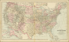
![Colton's United States Shewing Military Stations, Forts &c. . . . 1861 [Shows Colorada!]](https://storage.googleapis.com/raremaps/img/small/95088.jpg)