|
||

|

|
|

|
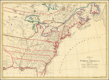
One of the Earliest Maps to Name the United States
Brion de La Tour's map is one of the earliest obtainable maps to name the United States (Etats Unis de L'Amerique Septentrionale).
The map shows the 13 Colonies, pre-dating the appearance of Vermont. Maine is named, as "Main de Massachusetts." The extent of the newly created United States extends to the Alleghanies and Appalachians, although the names run beyond the engraved border.
The west identified various forts, settlements, Indian tribes, etc. The Country of the Six Nations is shown, as are a number of early Western Forts.
Louis Brion de la Tour (ca. 1743-1803) was a French geographer and demographer. Little is known about Louis’ early life, but some glimpses of his professional life survive. He did achieve the title of Ingénieur Géographe du Roi. Much of his work was done in partnership with Louis Charles Desnos, who was bookseller and geographical engineer for globes to the Danish Crown. He worked on the Indicateur fidèle ou guide des voyageurs, qui enseigne toutes les routes royales between 1762 and 1785. During his career he also worked on several atlases. By 1795, he had gained a pension from the National Assembly. Perhaps this pension was granted in part because his son, also Louis Brion de la Tour (1763-1823), was an engraver who made Revolutionary prints, as well as maps.

![[First State of the Popple Key Sheet] A Map of the British Empire in America with the French and Spanish Settlements adjacent thereto by Hen. Popple.](https://storage.googleapis.com/raremaps/img/small/92714.jpg)