


|
||

|

|
|

|
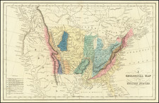
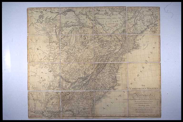
Rare meticulously compiled map of the United States, published in Nuremberg by Schneider und Weigelschen in 1819.
This exceptionally detailed map relies on a number of the most important early maps and sources for its content, including
- Arrowsmith's map of the United States (1795)
- Lewis' map of the United States (1796)
- D.F. Sotzmann's maps of the United States and 10 of the individual States, issued at the end of the 18th Century and up to 1804
- The writings of Christopher Ebeling, a German scholar who undertook an exhaustive study of America at the end of the 18th Century is a celebrated landmark and was the source material for Sotzmann's maps, which were intended as an Atlas of America, but resulted in the production of only 10 state maps.
The present map seems to be an updated version of the 1799 Schneider und Weigelschen map of the United States and D.F. Sotzmann's own map of the United States, dated 1804, which apparently utilized the Schneider und Weigelschen copper plate. The map notes that this edition of the map was revised and corrected by I.E. Diewald.
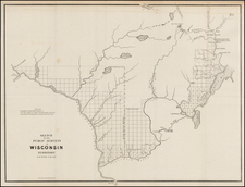
The map is extremely well researched and includes marvelous annoations throughout. One of the most noteworthy features is the massive depiction of Illinois Territory. Unlike other maps of the period, this map provides a more reliable general location for Illinois Territory, but shows Illinois extending to Lake Superior and the Lake of the Woods, without question the largest depiction we have ever seen, extending far into modern day Canada. Many Indian Tribes are noted and as are the locations of the Illinois Company (Illianeer Gesellschaft) and the New Jersey Company (Jersey Gesllsch). In the northeast of Illinois, the boundary is shown following the Wabash River a bit too far northeast, resulting in a large encroachment into Indiana. This encroachment was the result of a misreading of the definition of Illinois's eastern boundary, which tracks the boundary to Ft. Joseph, rather than proceeding due north from Fort Vincennes.
The boundaries reflect one of the few extent map depictions of the whole of Illinois Territory, which existed as a territory from 1809 to 1818. The Illinois Territory originally included lands that became the states of Illinois, Wisconsin, the eastern portion of Minnesota, and the western portion of the upper peninsula of Michigan. As Illinois was preparing to become a state, the remaining area of the territory was attached to the Michigan Territory.
The original boundaries of the Territory were defined as follows: "...all that part of the Indiana Territory which lies west of the Wabash River, and a direct line drawn from the said Wabash river and Post Vincennes, due north to the territorial line between the United States and Canada..."
Indiana takes on a curious mishapen form, in part due to the Illinois encroachment and in part due to the maker's decision to extend Ohio only as far west and to the westernmost part of Lake Erie. The entire Ohio Valley shows the influences of Thomas Hutchins' map and the wide spread attempts to settle this region after the American Revolution.
To the South, the map shows a massive Mississippi Territory, pre-dating the appearance of Alabama Territory, which had become a territory in 1817.
This map utilizes the same plate as D.F. Sotzmann's General Map of the United States dated 1804. It is almost certain that Sotzmann's map is drawn from the same plate. Copies of the 1804 Sotzmann are extremely rare.
An earlier variant, without Sotzmann's name but otherwise apparently identical in content and also published by Schneider und Weigelschen, can be found in the British Library and Yale map collections, along with the collection of the Pennsylvania Historical collection.
The present state of the map is extremely rare. We note only a dissected copy on Linen, at McMaster University. library.mcmaster.ca/maps/images/raremaps/9282-3.jpg
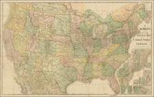
![[Shows Republic of Texas] United States and Texas](https://storage.googleapis.com/raremaps/img/small/101139.jpg)