


|
||

|

|
|

|
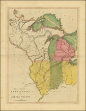
Nice example of Jedidiah Morse's depiction of the northern part of Abraham Bradley's postal map of he United States, published in 1796.
Abraham Bradley's map was the first American Postal map and one of the earliest large format maps printed in America to extend to the Mississippi River. It is also one of the few contemporary maps to identify the 5 proposed states of the Ordinance of 1789, as conceived by Thomas Jefferson.
Cincinnatus is shown. Chicago is shown, along with Detroit. A number of early forts appear. The Land of the Six Nations is shown, as are New Connecticut, Ohio Company lands, the Seven Ranges, Ft. Knox, Ft. Vincennes, Ft. Hamilton, General Wayne's Treaty Line, Ft. Wayne, Ft. Miami, Ft. Franklin, early portages, and many notes on the regions in the west.
First issued in 1796 (northeast sheet only), Bradley's postal map is among the most important maps in American history. It is one of only 4 large format maps of the United States to have been published in America prior to 1800, two of which (maps by Abel Buell and John Norman) are unlikely to ever again appear on the market. The map provides an exceptionally detailed look at the post offices and postal routes of America, as they existed at the end of the 18th Century, locating every post office then in operation. The map also includes the first printing of the first American postal delivery time and route schedule (which may have also been issued separately, although there are no known separately printed examples which have survived).
In 1796, Bradley published his first Map of the United States, Exhibiting the Post-Roads, the Situations, Connections, and Distances of the Post-Offices. At that time, less than 15 years after the end of the War of Independence, most citizens of the fledgling United States still had no real conception of the magnitude of their young nation. Bradley's postal map, with its schedule chart, was a perfect combination of Bradley's skills and obsession for precision scheduling. This unique U.S. map was on public display in almost every large post office in the country and provided citizens with an impressive visual depiction of the scope of the United States at a time when the search for a national culture and national identity was at its height, after the final and official separation from Great Britain. The inclusion of stagecoach schedules promoted, encouraged and broadened popular notions of the concept of time beyond seasonal and religious practices.
For many colonial residents, the Bradley's map was the iconic symbol of a unified United States. Citizens began to consider (and later demand adherence to) weekly and daily notations of time, as measured by the institution of regularly-scheduled mail service.
The present example is the second state of the map, with title word "Part" changed to "Parts."
Abraham Bradley was born in Litchfield, Connecticut. He is an important figure not only in early American cartography, but in early American history as well. Initially, Bradley trained as a lawyer and moved to the Wyoming Valley of Pennsylvania to practice. There he met Judge Thomas Pickering, who took Bradley with him to Philadelphia when he was appointed Postmaster General by George Washington in 1791.
As Pickering's clerk, Bradley created postal maps which showed the budding system of post offices and routes. A self-taught mapmaker, Bradley quickly gained considerable skill and became well-known for this carefully drawn maps. His most famous map is the postal route map of 1796, which shows the young United States and includes an innovative table that calculated the time it would take a letter to travel around the country.
In 1799, Bradley was appointed Assistant Postmaster General, a position he would hold until 1829. As part of his duties, Bradley supervised the moving of the General Post Office Department from Philadelphia to Washington DC. In 1804, with the help of British mapmaker Aaron Arrowsmith, Bradley updated his postal map, which featured in practically every post office in the states and territories. Bradley would continue to create route maps, and to update his most famous map, throughout his career, including in 1810 and 1825.
During the burning of Washington DC in the War of 1812, Bradley housed the records and archives of the General Post Office Department in his Maryland farmhouse. His service with the Post Office came to an abrupt end, however, with the election of Andrew Jackson. Although he had served under five Postmasters General, Jackson dismissed Bradley for partisan reasons. Bradley then served as secretary to the Franklin Insurance Company. He died at his farmhouse in 1838, leaving behind eight children. He is remembered for his careful custodianship of the nascent Post Office, and for creating maps that made Americans feel connected to their fellow citizens.


![La Florida [with] Guastecan [with] Peruviae Auriferae Regionis Typus](https://storage.googleapis.com/raremaps/img/small/84003.jpg)
![[ The Marks of Sundry of the Chief Men of Virginia ] Aliquot Heroum Virginiae Notae.](https://storage.googleapis.com/raremaps/img/small/98859.jpg)