|
||

|

|
|

|
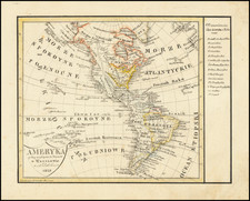
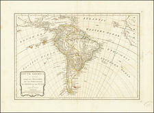
Interesting map of America, during the early years of the War of Jenkin's Ear.
The map shows the Continent of North America largely dominated by French claims, other than a narrow band along the East Coast of North America. In fact, no reference to Florida is made, nor any acknowledgement of Spanish claims in North America, save for the area identified as Nouvelle Espagne.
In South America, the route of the Amazon River and unnamed Andes Mountains dominated the geographical features of the interior of the continent.
The War of Jenkins' Ear was a conflict between Great Britain and Spain that lasted from 1739 to 1748, with major operations largely ended by 1742. Its unusual name, coined by Thomas Carlyle, in 1858, refers to an ear severed from Robert Jenkins, captain of a British merchant ship. The severed ear was subsequently exhibited before the British Parliament. The tale of the ear's separation from Jenkins, following the boarding of his vessel by Spanish coast guards, in 1731, provided the impetus to war against the Spanish Empire, ostensibly to encourage the Spanish not to renege on the lucrative asiento contract (permission to sell slaves in Spanish America).