|
||

|

|
|

|
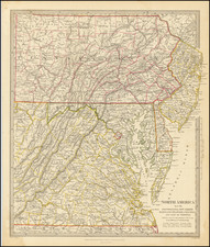
Rare broadside pictorial view / map of the "Middle States," published in Boston by J.H. Bufford, Paris & London by Goupil & Co., and M. Knoedler in New York City.
A huge and extraordinarily rare bird's-eye view of the theatre of conflict at the opening of the American Civil War.
Drawn from an imaginary viewpoint far above the DelMarVa Peninsula, the view extends from Chesapeake Bay in the foreground to encompass the Appalachians and the watersheds of the Ohio and Mississippi Rivers. Designed for an audience on the home front rather than for use in the field, it shows cities and towns, roads and railroads, and areas of elevation and waterways, without however any particular attention to scale or geographic precision. Tables in the left and right margins show distances by rail between Washington, D.C.; Cairo, Illinois; St. Louis, Missouri and other parts of the country.
The map tracks the Mississippi as far south as Memphis. The whole is centered on Louisville Kentucky and the Ohio River Valley.
The "balloon view" or "bird's-eye" perspective had been used for centuries to depict urban areas, but this view is remarkable for applying the technique to a vast region comprising hundreds of thousands of square miles. In the 1850s, English publishers began to employ this style to depict the regions during the Crimean War, but Bufford may have been the first to apply this style in America, perhaps in part through his connection to Goupil.
This unique pictographic style made the topographical information more accessible to a large public that may not have been conversant with map reading, but sought a geographic context with which to follow news of the Civil War. It did so, however, at the expense of extraordinary spatial distortion, with the mid-Atlantic states in particular suffering from substantial East-West compression. Others in the United States also applied the technique, most notably John Bachmann in his six-sheet Panorama of the Seat of War series, but Bufford's was likely the first, and was certainly the most ambitious attempt to cram so much into a single image.
OCLC lists two copies (Massachusetts Historical Society and Virginia State Historical Society). This is the first example of this map/view we have ever seen on the market.