


|
||

|

|
|

|
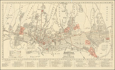
Exceedingly rare plan of Lahaina and its anchorages, the earliest obtainable map of Maui based upon actual surveys.
This coastal charting of Lahaina, Maui, "Plan de la Rade de Raheina", is of primary importance as it shows the location of the home sites during that pivotal year when the final kapus (the ancient Hawaiian system of laws), were overturned by Queen Kaahumanu and Kamehameha II, and the islands embraced Christianity.
The map was drafted by Louis-Isadore Duperrey, Chief Hydrographic Surveyor on Freycinet's 3 year expedition to the Pacific.. The Uranie was the first major European ship to arrive in Hawaii after the death of Kamehameha I.
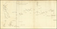
This finely executed map is based upon the surveys taken by Louis-Isidore Duperrey, who participated in the Louis de Freycinet's second circumnavigation. In 1817, Freycinet set sail on his second major voyage on the Uranie, in which Louis Isidore Duperrey, Jacques Arago, Adrien Taunay the Younger, and others, went to Rio de Janeiro, to take a series of pendulum measurements. It was a larger scheme for obtaining observations, not only in geography and ethnology, but in astronomy, terrestrial magnetism, and meteorology, and for the collection of specimens in natural history. The voyage lasted for 3 years, visiting Australia, the Mariana Islands, Hawaiian Islands, and other Pacific islands, South America, and other places, and, notwithstanding the loss of the Uranie on the Falkland Islands during the return voyage, returned to France with fine collections in all departments of natural history, and with voluminous notes and drawings of the countries visited.
The results of this voyage were published under Freycinet's supervision in monumental work of 17 volumes, with the title of Voyage autour du monde fait par ordre du Roi sur les corvettes de S. M. l'Uranie et la Physicienne, pendant les années 1817, 1818, 1819 et 1820, consisting of 13 quarto volumes and 4 folio volumes of plates and maps.
The map is exceedingly rare, this being only the second example we have ever seen on the market in over 20 years.

![Hawaiian Group or Sandwich Islands [with] New Zealand [and] Feejee Group, Society Island, Marquesas and Galapagos Islands](https://storage.googleapis.com/raremaps/img/small/75676.jpg)