|
||

|

|
|

|
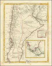
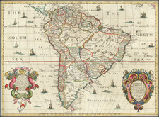
Fine example of the rare first edition of Pierre Du Val's separately issued map of El Dorado and the country of the Amazons, first published in 1654.
Du Val's map is quite possibly the earliest printed map to reference the name El Dorado in the title of the map, which loosely translates as Guaina or the Savage Coast, also known as El Dorado and the Country of the Amazons. The map demonstrates the contemporary importance of the legend of El Dorado, which is featured in the map title, with Guaiana referred to as "Royaume du Roy doré" (Kingdom of the Golden King). The mythical Lac Parimbe is also illustrated, with El Dorado (Manoa) very prominently located on the far western shores of the map.
The mouth of the Amazon River is depicted in great (if inaccurate) detail, with annotations reflecting the first navigation of the length of the Amazon from Peru and the Andes in the west, to the mouth of the River, undertaken in an expedition of 1541-42 by Francisco de Orellana. The map refers to the Amazon River as "R.de S. Juan de las Amazones o d'Oregliana", reflecting the time period for which the map was briefly named for Orellana.
A number of other historical annotations dot the coastline from Santa Margarita Island to the mouth of the Amazon River, with fine detailed in the interior.
El Dorado was originally El Hombre Dorado (the golden man), El Indio Dorado (the golden Indian), or El Rey Dorado (the golden king). This is the mythical name used by Europeans to describe a tribal chief of the Muisca native people of Colombia, South America, who as an initiation rite, covered himself with gold dust and dived into Lake Guatavita. Imagined as a place, El Dorado went from a city to a kingdom and an empire of this legendary golden king. In pursuit of the legend, Spanish conquistadors Francisco Orellana and Gonzalo Pizarro departed from Quito (now capital of Ecuador) in 1541, in an expedition towards the Amazon Basin, as a result of which Orellana became the first known person to navigate the entire length of the Amazon River.
The concept of El Dorado underwent several transformations, and eventually accounts of the previous myth were also combined with those of a legendary lost city. The resulting El Dorado myth enticed European explorers for two centuries. Among the earliest alleged stories was the one told on his death bed by "Martinez", ammunitioner for Spanish adventurer Diego de Ordaz, who claimed to have been rescued from shipwreck, conveyed inland, and entertained by "El Dorado" himself (1531). The fable of Juan Martinez was founded on the adventures of Juan Martin de Albujar, well known to the Spanish historians of the Conquest; and who, in the expedition of Pedro de Silva (1570), fell into the hands of the Caribs of the Lower Orinoco.
In the 16th and 17th centuries, Europeans still believed that a hidden city of immense wealth existed. Many searched for this treasure, in quests that ended in the loss of countless lives. The illustration of El Dorado's location on maps only made matters worse, as it made some people think that the city of El Dorado's existence had been confirmed. The mythical city of El Dorado on Lake Parime was marked on maps until its existence was disproved by Alexander von Humboldt during his Latin-America expedition.
The present map identifies "Guiana ou Roiaume du Roy doré."
This map is extremely rare. A later edition by Jollain (1668) is also known. Copies of this map reside in the Bibliotheque Nationale de France and the Collection of George III (British Library) and the Clements Library.
Pierre Duval (1618-1683) was a French geographer, cartographer, and publisher who worked in Abbeville and Paris during the seventeenth century. He was born in the former city, in northeast France, before moving to Paris. Duval was the nephew of the famous cartographer Nicolas Sanson, from whom he learned the mapmaker's art and skills. Both men worked at the royal court, having followed the royal request for artists to relocate to Paris. In addition to numerous maps and atlases, Du Val's opus also includes geography texts. He held the title of geographe ordinaire du roi from 1650 and died in 1683, when his wife and daughters took over his business.