|
||

|

|
|

|
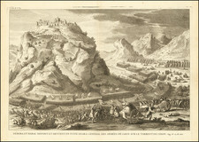
Nice example of the earliest obtainable map of the Holy Land with Hebrew lettering and the first map of Eretz Israel known in a Jewish publication, first issued in 1695.
Bar Yaaqov's map appeared in Moses Wesel's Amsterdam edition of the Passover Haggadah. For many years, it was believed to be the first map of the Holy Land printed in Hebrew until the recent discovery of a 1621 map described by Nebenzahl (plate 40).
Bar Yaaqov bases his map on Christian Van Adrichom's map of the Holy Land. The map traces both Jacob's route to Egypt and the route of the Exodus and notes the locations of 41 encampments of the Israelites in the wilderness. Various sacred icons of Judaism are illustrated along the bottom.
By the end of the fifteenth century, Hebrew books were produced using movable type. During the fifteenth century, Hebrew printing was restricted mainly to the Italian and Iberian peninsulas, where some 180 Hebrew titles were issued. While Hebrew printing ceased in Spain and Portugal after the expulsion of the Jews in 1492, it quickly spread to the Ottoman Empire, North Africa, and Central and Eastern Europe.
In 1617, the heads of the Jewish school in Amsterdam voted to establish a printing press. Within the decade, several private Hebrew presses were also set up including that operated by the renowned intellectual Menasseh ben Israel. During its first twenty years, his multilingual press produced more than sixty titles, including Bibles, prayerbooks, and his own original works. Well known among the philosophers, scientists, and theologians of Amsterdam, he gave sermons that attracted flocks of Christians as well as Jews, and would even represent his enterprise at the Frankfurt Book Fair in 1634.
By the close of the 17th century and throughout the 18th century, Amsterdam was the center of Hebrew printing for the entire world, supplanting Venice as the most important city for printed works in Hebrew. In addition, most of the religious literature in Spanish and Portuguese intended for the guidance of the Sephardi communities was composed and printed in Amsterdam. The Amsterdam Haggadah map is an example of the confluence of the Dutch tradition of mapmaking and illustrating Bibles with maps and the rise of Hebrew printing in Amsterdam. The influence of Dutch printing and engraving styles on the Hebrew printing and publishing business was profound.
The map appeared in 4 editions of the Haggadah Shel Pessach, 1695, 1712, 1781 and 1810. This example is likely from a later edition of the Haggadah, but is remarkably well preserved for a map which was included in a book which would have been used twice a year at the dinner table and had significant exposure to food and wine.
![[Holy Land]](https://storage.googleapis.com/raremaps/img/small/81990.jpg)
![(Nuremberg Chronicle Leaf) [Moses and the Burning Bush]](https://storage.googleapis.com/raremaps/img/small/98578.jpg)