|
||

|

|
|

|
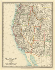
Rare map of Texas, the American Southwest and Mexico, published by George Bauerkeller in Darmstadt.
The map incorporates the work of a number of important early mapmakers, which are listed in the title, including;
- Humboldt's map of Mexico (1811)
- Fremont's Map of the West (1843-44)
- Emory's map of the Arkansas and Rio Del Norte and Rio Gila (1847)
- Simpson's map of the route from Ft. Smith to Santa Fe (1849)
- Wislezenus map of Texas (1845)
- Duflot du Mofras' map of the West (1844)
- Disturnell's Map of the Republic of Mexico (1847)
- Roemer map of Texas (1849)
- Pressler & Volker Map of Texas (1851)
- J. Calvin Smith Map ofthe US (1848)
- The Guadalupe Victoria Coastal Atlas of Mexico (1826)
- The Royal Geographical Society of London's Journals (Vol III, IV and V)
The map was published shortly after Texas received its Statehood, but prior to the Gadsden Purchase. The map is perhaps most noteworthy for its location of several dozen IndianTribes in the United States and the highly precise depiction of the known river systems.
Bauerkeller's maps employ a unique printing process which combines letterpress, color lithography, and metal plate printing. His work is quite unique and enjoys an unusual visual appeal. Relatively little is known about Bauerkeller. He is best known for inventing a type of relief printing for city maps called "geomontographie." The city blocks with buildings are raised in white, while streets, squares, parks & rivers are printed in colors.
HIs work is very rare on the market, this being the first example of this map we have ever seen on the market.
![(Texas Mexico Borderlands) [Map of the Rio Grande, Texas - Mexico border, from the Big Bend to the town of Mier] Copiado del Mapa de S. Mc. L. Staples, 1828... Dibujado y extractado de los documentos y datos dichos, por F. L. Mier - Monterey, Diciembre de 1873.](https://storage.googleapis.com/raremaps/img/small/91667.jpg)
![(Mexican-Aztec Painting) [Watercolor of three Aztec deities from the Codex Vaticanus:] Toxcatl, God of Droughts and Inundations. Cod. Vat. Tlaloc. God of Water. Cod. Vat. Tecuilvitontl [Tecuilhuitontli] The Lesser Festival of the Lords. Cod. Vat.](https://storage.googleapis.com/raremaps/img/small/103009.jpg)