|
||

|

|
|

|
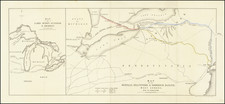
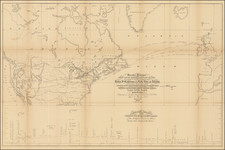
Finely excecuted map of Fort Levis on Isle Royal (now Chimney Island), showing the British Siege of Fort Levis under the Command of Amherst, in August, 1760, from Pierre Pouchot's Memoires sur le derniere guerre de L'Amerique Septentrionale.
The map shows the siege of Fort Levis by the English, under the command of Brigadier General Jeffery Amherst, from August 16 to August 24, 1760. After the fall of Quebec in 1759, the English conducted three expeditions against French posts in the interior of French Canada. One ascended the St. Lawrence from Quebec, the second advanced upon Montreal, from Lake Champlain, while the third, under Amherst, came down from Oswego and encountered on the way, the fortifications of Fort Levis on Isle Royale.
This fortress had been constructed during the previous year, 1759, by M. the Chevelier de Levis, on an island called by the Indians, Oraconenton (Chimney Island), situated just above the rapids. Following his arrival, Pouchot set about strengthening the fort, which had been originally designed to include stone walls, 200 guns and some 2,500 troops. What Pouchot actually found was a small fort with wooden stockades, five cannon and 200 soldiers.
The Siege depicted was a part of the Siege of Thousand Islands, otherwise known as the Siege of Montreal, which lasted from August 16 to August 26, 1760. The attack on Fort Levis commenced on August 19, and included the British ships Williamson, Mohawk and Onondaga. On August 20, the French sunk the Willliamson and Onondaga, while the Mohawk ran aground. The British batteries on the neighboring islands continued to lay siege to Fort Levis until Pouchot's forces ran out of amunition on August 24, 1760.
The British renamed Fort Levis, Fort William Augustus. They raised the three ships sunk during the battle and put them back into service to patrol the waters between the fort and Fort Niagara.
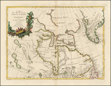
Streeter calls Pouchet's 3 volume work, published posthumously in Yverdon in 1781, a "contemporary authority of the first importance from the French point of view." Justin Winsor calls this work, "Foremost among the special histories of the war . . . ," and points out its usefullness "in the study of topography, so far as it was known and of the geographical nomenclature of the frontier just previous to the outbreak of the Revolutionary War . . ."
Pouchot, a professional French soldier and engineer, came to Canada in 1755, with the Bearn regiment. He was initially posted to Fort Frontenac (Kingston, Ontario), where the superior quality of the entrenchments which he constructed, led Governor Vaudreuil to entrust him with the rebuilding of the defenses of Fort Niagara. Following exemplary service in the capture of Chouagüen (Oswego) in 1756, Pouchot was appointed by Vaudreuil, on the advice of Montcalm, commandant of Fort Niagara, to be the first officer in the French regular army to hold the post. The first two volumes are the history of the war from 1754 to 1760, including details of Indian warfare and accounts of their manners and customs. The third volume is devoted to a topographical account of Canada.