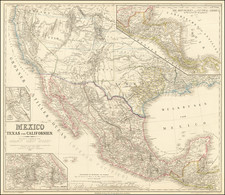
|
||

|

|
|

|
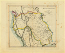
Rare map of a section of the Mississippi River, centered on St. Louis. Based upon an earlier survey by Robert E. Lee, conducted in 1837, which appeared in Report of the Chief Topographical Engineer," in Public Documents Printed by Order of the Senate of the United States vol. 1 (1843)
This map runs from Cascarot Island in the north to Bloody Island opposite Saint Louis, to Dunstand Island just below Saint Louis, and to Cahoe Island in the south. Churchill's Mill is identified, as is Pages Mills and the U.S. Arsenal.
This map is based on a survey conducted by Robert E. Lee in 1837. It shows his plans for the construction of a dam from the head of Bloody Island to the Illinois shore, a revetment (a surface for an embankment) to protect the western shore of the island and a long dike extending south from the bottom of the island.
Steamboat traffic in the St. Louis vicinity was growing rapidly with westward expansion, and this influence was manifested in St. Louis by the animated appearance of its levee and the start of local steamboat construction. The wharf was partially improved and paved after 1831, when the last vestiges of the stone bluff had disappeared. During this time period, the Mississippi River passed St. Louis in two streams of equal size divided by Bloody Island, now part of East St. Louis. This island was so named because it was the scene of numerous duels.
The current in the stream washing the City's levee was diminishing and threatened to leave the City high and dry if not altered. This resulted in the deposit of much silt below the town, creating Duncan's Island, which impeded navigation to the extent that no steamboat could land below Market Street. Major Robert E. Lee was sent here to supervise channel work. The work was delayed by owners of town lots in Illinoistown who brought an injunction suit against the operations. This however, resulted in a better plan which ultimately joined Bloody Island to the Illinois shore, by a dyke system. This channel change caused Duncan's Island to be washed away by the strong current on the St. Louis side of the river.
Lee was promoted to Captain in 1838 and remained in St. Louis until 1840.