


|
||

|

|
|

|
1870 facsimile edition of this extraordinary map of the area around Philadelphia, as surveyed by Thomas Holme at the request of William Penn.
Holme's map has been called "the greatest of early American maps." It is without question the most extraordinary wall map of any British Colony published in the 17th Century and both a visual and cartographic masterpiece.
As stated by Philip Burden, "This monumental work is without question the finest printed cartographic document relating to North America to be published to date." No other English American colony was mapped in the seventeenth century on such a large scale, and in such amazing detail.
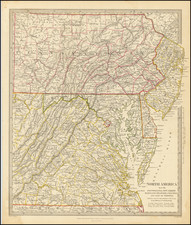
In 1681, William Penn was granted sole proprietorship to more than forty-five thousand square miles in a region that he named Pennsylvania. Through vigorous promotion more than a half-million acres were sold in the first year alone. Because each tract had to be laid out before it could be developed, Penn appointed Thomas Holme surveyor general of the colony in April 1682. Holme immediately began to survey the land and to lay out the future city of Philadelphia. A plan titled
A Portraiture of the City of Philadelphia was published in 1683. Penn then pressured Holme to produce a general map of the colony complaining from London that "we want a map to the degree that I am ashamed here … all cry out, where is your map, what no map of the settlements!"
The completed manuscript was on its way to Penn in London by May 1687 and the finished map was advertised in January 1688. It illustrates the "improved", or settled area of the province, along the western bank of the Delaware River, a tract of approximately fifty-five miles in length and thirty-three miles in width. On a scale of one mile to one inch, it locates the holdings of 670 settlers and was the only map of any English colony to give such a detailed account of settlement. Holme's 1683 plan of Philadelphia, the first published for any English American city, was included in reduced form as an inset in the upper right corner. The map's prolific size insured its rarity over time. A reduced version was published by Philip Lea around 1690.
The map is offered here in the second state (of two). State one survives in a single example at the British Library, believed to be the copy given to William Penn. It has Neshaminy Creek flowing above the letters "KS Coun" in the name "Bucks County". Copies of the second state are at the Historical Society of Pennsylvania, Winterthur and Library of Congress (altered to show with the creek flowing below the letters "S C" in the county's name). We also found references to copies at Library [Company] of Philadelphia [which could be same as HSP copy], American Philosophical Society, and the Pennsylvania State Library; in addition WorldCat shows copies at the national libraries of both France and Spain.
The full title reads. [Across the Top]: A Map of the Improved Part of the Province of Pennsilvania in America. Begun by Wil: Penn Proprietary and Governour thereof Anno 1681. [Decorative cartouche to right]: A Map of the Province of Pennsilvania. Containing the three Countyes of Chester, Philadelphia, & Bucks, as far as yet Surveyed and Laid out…. Sold by Rob: Greene at the Rose & Crowne in Budg. Row, and by John Thornton at the Platt in the Minories.
The original map is essentially unobtainable, making this 19th Century facsimile edition the only realistically obtainable edition of the map.
![[Jefferson's Notes on the State of Virginia] Observations sur la Virginie [with the map:] A Map of the country between Albemarle Sound, and Lake Erie, comprehending the whole of Virginia, Maryland, Delaware, and Pensylvania, with parts of several other of the United States of America. Engraved for the Notes on Virginia.](https://storage.googleapis.com/raremaps/img/small/51828.jpg)
![[Rare First State] Novissima Tabula Regionis Ludovicianae Gallice dictae la Louisiane . . .](https://storage.googleapis.com/raremaps/img/small/72622.jpg)