This item has been sold, but you can enter your email address to be notified if another example becomes available.


|
||

|

|
|

|
Stock# 39207
Description
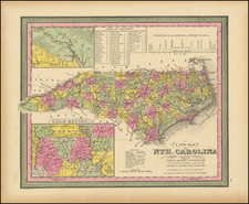
Rare 1816 example of Mathew Carey's map of North Carolina, from Carey's General Atlas.
The map is one of the earliest obtainable folio sized maps of North Carolina. The map is colored by counties and locates towns, roads, rivers, mountains, court houses, etc.
Carey first published his American Atlas in 1795, which became the first folio atlas published in America. He later issued General Atlases in 1796 and after. In 1814, he became the first American publisher to offer hand coloring.
An essential map for North Carolina collectors.
Condition Description
Minor discoloration at centerfold

![[ Virginia / Mouth of the Chesapeake Bay ] A Draught of Virginia from the Capes to York in York River and to Kuiquotan or Hamton in James River by Mark Tiddeman](https://storage.googleapis.com/raremaps/img/small/103814.jpg)
![[ Cape Hatteras to New York City ] The Coast of the United States of North America; from New York to St. Augustine: Drawn and regulated according to the latest Surveys and Astronomical Observations By Edmund Blunt. Additions to 1839 & 1840](https://storage.googleapis.com/raremaps/img/small/84684.jpg)
![[ Cherokee Nation ] A Map of the Tennassee Government formerly Part of North Carolina from the latest Surveys. 1795.](https://storage.googleapis.com/raremaps/img/small/100899.jpg)