|
||

|

|
|

|
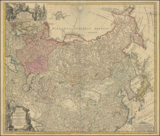
Finely engraved map of the North Pacific and contiguous coastlines of Alaska and Russia, published in the first French edition of the official account of James Cook's Third Voyage.
The present map is of the utmost importance in the cartographic history of the region. For the first time on a printed map the coastline of Alaska and the Northwest Coast is accurately portrayed. This was the official map to illustrate Capt. Cook's final voyage & displays his great contribution to the mapping of the area. Capt. Cook's route in the northern Pacific is shown in detail.
As noted in the map's legend below the title, the map is in part drawn from a Russian manuscript map.
Cook's chart is of tremendous importance, providing a highly important advance in the mapping of the coastlines depicted on the map. It is also a map of great controversy, having been the subject of an internal struggle among the editors of Cook's official account of his third voyage and those who actually accompanied Cook on his final voyage and were present at the time the obsevations were taken.
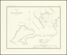
An important map in the cartographic history of the Northwest Coast of America and Polar Exploration, made all the more interesting by its unique printing history.
![[Map of Russian Possessions in North America] Карта Российскаго Владѣнія въ Сѣверной Америкѣ](https://storage.googleapis.com/raremaps/img/small/66569.jpg)
![[ Karte des Nordens von America, Zur Beurtheilung der Wahrscheinlichkeit einer nord=westlichen Durchfhart, gezeichnet von G. Forster, 1791.]](https://storage.googleapis.com/raremaps/img/small/41816dm.jpg)