This item has been sold, but you can enter your email address to be notified if another example becomes available.


|
||

|

|
|

|
Stock# 39154se
Description
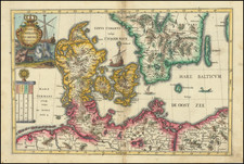
Striking sea chart of the Southern part of Denmark and contiguous German Coastline, with a large inset of the area around Copehangen, published by Jacob Colom.
Jacob Colom and Arnold Colom were a family of well regarded Amsterdam booksellers, printers, and chartmakers. The Coloms produced several sea atlases, a guide and pilot for the Mediterranean and a general sea atlas of the World. Colom's Zee Atlas, published between 1654-58, was one of the largest format sea atlases of the 17th Century with each chart printed from an oversized copper plate. Koeman describes the atlas as "One of the most important atlases in the well known category of Dutch sea-atlases."
![[ Germany -- Embellished with Animals ] Tabula Europae IIII](https://storage.googleapis.com/raremaps/img/small/100690.jpg)