


|
||

|

|
|

|
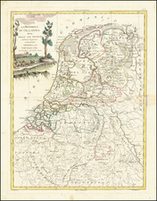
A striking example of Blaeu's rare early map of Holland, remarkable for its intense decorative elements.
This map, engraved early in Blaeu's career, stands out with its vivid imagery. The imagery includes more than a dozen naval vessels spread throughout the north coast and Holland's inland seas. These range from various types of fishing vessels to Dutch ships of the line. A sea monster can also be seen in the southwest of the map. The cartouches, compass roses, and coats of arms are all magnificently engraved as well. Below the map are the thirty-two coats of arms of the major cities of the Netherlands along the bottom.
The cartography shows the many twisting waterways and canals of the Low Countries that interconnect the main cities. Depth soundings are shown in the ocean, as are the dangerous sandbars.
States
This edition of the map is from the 1635 French edition of Blaeu's Theatrum. It was only issued as part of an atlas in this edition of the Theatrum and Blaeu's Appendix. The map was also separately issued.
Willem Janszoon Blaeu (1571-1638) was a prominent Dutch geographer and publisher. Born the son of a herring merchant, Blaeu chose not fish but mathematics and astronomy for his focus. He studied with the famous Danish astronomer Tycho Brahe, with whom he honed his instrument and globe making skills. Blaeu set up shop in Amsterdam, where he sold instruments and globes, published maps, and edited the works of intellectuals like Descartes and Hugo Grotius. In 1635, he released his atlas, Theatrum Orbis Terrarum, sive, Atlas novus.
Willem died in 1638. He had two sons, Cornelis (1610-1648) and Joan (1596-1673). Joan trained as a lawyer, but joined his father’s business rather than practice. After his father’s death, the brothers took over their father’s shop and Joan took on his work as hydrographer to the Dutch East India Company. Later in life, Joan would modify and greatly expand his father’s Atlas novus, eventually releasing his masterpiece, the Atlas maior, between 1662 and 1672.
![[ Utrecht ] Ultraiectum Dominium](https://storage.googleapis.com/raremaps/img/small/99279.jpg)
![Mechlinia [Mechelen]](https://storage.googleapis.com/raremaps/img/small/80595.jpg)
![[Holy Roman Empire] A Newe Mape of Germany Newly Augmented by Iohn Speed Ano Dom: 1626](https://storage.googleapis.com/raremaps/img/small/67323.jpg)