|
||

|

|
|

|
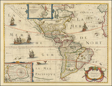
Fine wall map of America, published in Paris by Jean Baptiste Louis Clouet.
Beginning in the 17th Century, wall maps became objects of art for the educated and affluent classes of Europe, especially in France and other parts of Western Europe where the merchant classes began to look outside of Europe for trading partners. Maps such as the present map were created for the salons and private libraries, as a means of demonstrating worldliness and education about the world beyond Europe's shores.
The present map combines a modern depiction of America as known immediately prior to the Voyages of James Cook became well documented. The Mer de L'Ouest (Bay of the West) remains, a cartographic myth which was just then being dispelled by Cook and other French and English explorers in the 1770s and 1780s. The alternate theory of the region, which Clouet attributes to Russian explorers, is depicted in the upper left corner of the map proper. The cartographic content of the map is largely bsed uon the work of Nicholas De L'Isle and Philippe Buache, the major French cartographers of the 18th Century.
The 20 vignettes surrounding the map offer a pictorial history of the new World, dating back to its discovery, with text explanations in both French and Spanish.
The map was issued in 1785, a period in which France was feeling a great lift in its spirits toward commercial opportunities in the New World, having recently helped the Americans liberate themselves from England and create the United States. French interests interests in Louisiana were again running high and French investors were very actively pouring money into speculative real estate investments in the Ohio Valley and Mississippi Valley.
A finely colored example of this striking map.
Jean-Baptiste Louis Clouet (1730-ca. 1790) was a mapmaker with premises in both Paris and Cadiz. He was eventually named Royal Geographer of the Academie des Sciences de Rouen. Although he made several lavish wall maps, he is best known for Geographie Moderne (1776-93).
![Carte de L'Amerique Nouvellement dressee suivant les Nouvelles descouvertes . . . 1661 [and] Carte Nouvelle de L'Europe Asie & Afrique Nouvellement . . .](https://storage.googleapis.com/raremaps/img/small/74198.jpg)