
This item has been sold, but you can enter your email address to be notified if another example becomes available.


|
||

|

|
|

|
Stock# 38991
Description
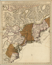
Scarce map of South Carolina based upon the De Brahm's very rare map, from the Universal Magazine.
Shows the path from the Cherokees, boundary line of 1772, old boundary line, forts, district line and early precincts, along with early roads, townships, towns, counties, rivers, lakes, mountains, inlets, islands, etc.
Reference
Jolly Univ-180.

![[Rare First State] Novissima Tabula Regionis Ludovicianae Gallice dictae la Louisiane . . .](https://storage.googleapis.com/raremaps/img/small/72622.jpg)
