


|
||

|

|
|

|
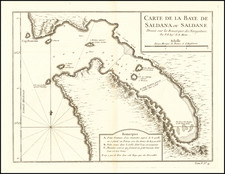
Created around 1750 by Jacques Nicolas Bellin, the Royal Hydrographer to the King of France, the plan of Saldanha Bay, located northwest of Cape Town in South Africa, is a small but practical navigational chart of the time.
The map includes soundings, which are depth measurements taken at different points within the bay. These soundings would have been used by sailors to identify safe areas for anchoring and to avoid underwater hazards.
Additionally, the map features specific remarks in a text box, providing further information about the region:
- A. There is mention of a small brackish water fountain near which a post with the King's Arms was placed in 1666, possibly marking a territorial claim.
- B. A warning is given about a well dug in the sand with bad water, directing sailors away from this non-potable source.
- C. Reference is made to several good-quality springs forming a small stream, directing sailors to a reliable source of fresh water.
- The text also notes that there is no wood in the bay, only brushwood, providing information on the local vegetation and the lack of substantial timber.
Bellin's detailed plan of Saldanha Bay reflects the need for accurate geographical information for navigation during the 18th century. It combines both scientific measurements and practical observations, resulting in a map that would have been a valuable tool for sailors of the time.
Jacques-Nicolas Bellin (1703-1772) was among the most important mapmakers of the eighteenth century. In 1721, at only the age of 18, he was appointed Hydrographer to the French Navy. In August 1741, he became the first Ingénieur de la Marine of the Dépôt des cartes et plans de la Marine (the French Hydrographic Office) and was named Official Hydrographer of the French King.
During his term as Official Hydrographer, the Dépôt was the one of the most active centers for the production of sea charts and maps in Europe. Their output included a folio-format sea atlas of France, the Neptune Francois. He also produced a number of sea atlases of the world, including the Atlas Maritime and the Hydrographie Francaise. These gained fame and distinction all over Europe and were republished throughout the eighteenth and even in the nineteenth century.
Bellin also produced smaller format maps such as the 1764 Petit Atlas Maritime, containing 580 finely-detailed charts. He also contributed a number of maps for the 15-volume Histoire Generale des Voyages of Antoine François Prévost.
Bellin set a very high standard of workmanship and accuracy, cementing France's leading role in European cartography and geography during this period. Many of his maps were copied by other mapmakers across the continent.
![[Southwestern Coast of Africa] Pas-Caart van Guinea en de Custen daer aen gelegen Van Cabo verde tot Cabo de Bona Esperanca](https://storage.googleapis.com/raremaps/img/small/46931.jpg)
![North Africa [with] South Africa](https://storage.googleapis.com/raremaps/img/small/48322.jpg)
![[ Cape of Good Hope / Cape Town, South Africa ] The Dutch Colony of the Cape of Good Hope by L.S. De La Rochette MDCC XCV](https://storage.googleapis.com/raremaps/img/small/96510.jpg)