|
||

|

|
|

|
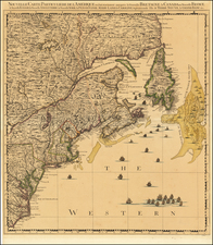
Fine example of Joseph Frederick Wallet Des Barres's detailed charting of Piscataqua Harbor and the area around Portsmouth, New Hampshire, first published in 1779, from his Atlantic Neptune.
The chart was compiled under the direction of Samuel Holland and J. F. W. Des Barres, as part of the first systematic attempt by any European power to make an extensive survey of areas overseas at a large scale.
This chart is devoted to Piscataqua Harbor, the City of Portsmouth. It was compiled under the direction of Holland, who had been appointed Surveyor General of the Northern District of North America in 1764. It is particularly important as Holland moved his headquarters to Portsmouth in 1770. Holland immediately began his survey of the area and the chart was published in January 1779.
The chart is centered on Piscataqua Harbor and depicts the coast between Hampton, New Hampshire and York, Maine, extending eastward to Duck Island, Hog Island and the other Shoal Islands. Several of these islands show signs of inhabitance. The chart extending inland for several miles, demonstrates Des Barres's remarkable attention to detail both in terms of the hydrographic data (including soundings, shoals, rocks and other hazards) and a fine representation of the coastal topography. A street plan of Portsmouth is also shown, along with the location of smaller towns, buildings and land-ownership boundaries along the coastline and contiguous regions.
Joseph Frederick Wallet Des Barres was born in Switzerland, where his Huguenot ancestors had fled following the repeal of the Edict of Nantes. He studied under the great mathematician Daniel Bernoulli at the University of Basel, before immigrating to Britain where he trained at the Royal Military College, Woolwich. Upon the outbreak of hostilities with France in 1756, he joined the British Royal American Regiment as a military engineer. He came to the attention of General James Wolfe, who appointed him to join his personal detail. During this period he also worked with the legendary future explorer James Cook on a monumental chart of the St. Lawrence River.
Upon the conclusion of the Seven Years War, Britain's empire in North America was greatly expanded and this required the creation of a master atlas featuring new and accurate sea charts for use by the Royal Navy. Des Barres was enlisted to survey the coastlines of Nova Scotia, Newfoundland and the Gulf of St. Lawrence. With these extremely accurate surveys in hand, Des Barres returned to London in 1774, where the Royal Navy charged him with the Herculean task of producing the atlas. He was gradually forwarded the manuscripts of numerous advanced surveys conducted by British cartographers in the American Colonies, Jamaica and Cuba. The present map is based on the work of Samuel Holland, conducted in the 1760s. The result was The Atlantic Neptune, which became the most celebrated sea atlas of its era, containing the first systematic survey of the east coast of North America. Des Barres's synergy of great empirical accuracy with the peerless artistic virtue of his aquatint views, created a work that "has been described as the most splendid collection of charts, plates and views ever published" ( National Maritime Museum Catalogue).
The Neptune eventually consisted of four volumes and Des Barres's dedication to the project was so strong that often, at his own expense, he continually updated and added new charts and views to various editions until 1784, producing over 250 charts and views, many appearing in several variations. All of these charts were immensely detailed, featuring both hydrographical and topographical information, such that in many cases they remained the most authoritative maps of the regions covered for several decades. Following the completion of The Neptune, Des Barres returned to Canada, where he remained for forty years, becoming a senior political figure and a wealthy land owner, living to the advanced age of 103.
Joseph Frederick Wallet Des Barres (1721-1824) was born in either Paris or Basel, Switzerland, to a Hugueont family. He studied under the great mathematician Daniel Bernoulli at the University of Basel before immigrating to Britain, where he trained at the Royal Military College, Woolwich.
Upon the outbreak of hostilities with France in 1756, he joined the British Royal American Regiment as a military engineer. He came to the attention of General James Wolfe, who was impressed with his charting ability. During this period, he also worked with the legendary future explorer, James Cook, on a monumental chart of the St. Lawrence River.
Des Barres is best known for the Atlantic Neptune, was a remarkable, multi-volume set of sea charts and coastal views prepared from recent surveys, some of which were overseen by Des Barres in Nova Scotia after the Seven Years’ War. The maps, charts, and views were prepared under the supervision of Des Barres and employed as many as twenty engravers and assistants. They were produced over the course of a decade, from 1774 to 1784, in time to be used by the Royal Navy in the American Revolution.
After the Revolution, Loyalists were resettled throughout Canada. As part of this process, a new colony was created by separating Cape Breton from Nova Scotia. Des Barres, who already owned extensive lands in the Maritimes, served as lieutenant governor of Cape Breton Island from 1784 to 1787. He later served as governor of Prince Edward Island from 1804-1812.
Des Barres lived an exceptionally long life, even by today's standards, finally dying at age 102. Des Barres' funeral was held at St. George's Round Church in 1824 and he is buried in Halifax.