|
||

|

|
|

|
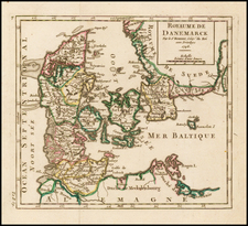
Fine example of the first edition of the detailed sea chart of the seas around Denmark, Norway, Sweden and the western Baltic by Alexis Hubert Jaillot in Paris, by order of the King of France.
This chart, which would be widely copied and reissued for the next 100 years by other makers, shows the whole of Denmark and the surrounding seas in great detail, including parts of the coasts of Norway, Sweden and Germany, with the port cities named.
Depth soundings are marked along the coasts, and sandbanks indicated. It includes 3 distance scales, rhumb lines with one and a half compass roses (north to the left) and two keys, indentifying coastal and shallow water features.
Alexis-Hubert Jaillot (ca. 1632-1712) was one of the most important French cartographers of the seventeenth century. Jaillot traveled to Paris with his brother, Simon, in 1657, hoping to take advantage of Louis XIV's call to the artists and scientists of France to settle and work in Paris. Originally a sculptor, he married the daughter of Nicholas Berey, Jeanne Berey, in 1664, and went into partnership with Nicholas Sanson's sons. Beginning in 1669, he re-engraved and often enlarged many of Sanson's maps, filling in the gap left by the destruction of the Blaeu's printing establishment in 1672.


![[Coppenhagen] Coppenhague Ville Capitale du Royaume de Danemarck elle est situe en Zeelande qui est une des Isles de la Mer Baltique.](https://storage.googleapis.com/raremaps/img/small/91655.jpg)